The Jhelum River is one of the primary tributaries of the Indus River System. It is the westernmost of the five rivers of the Punjab region and flows through India and Pakistan, playing an important role in ecology, agriculture, settlement, culture and hydropower.
In the Rigveda, the Jhelum River is referred to as Vitasta. Greek historians knew the Jhelum as Hydaspes. In 326 BCE, the Macedonian ruler Alexander the Great fought a decisive battle near the Hydaspes River against King Porus. In the local Kashmiri language, the Jhelum River is known as Vyeth.
Also read: Rigvedic, Ancient, and Greek Names of Rivers of the Indus Valley System
![]() Indian Geography: Indian Drainage System
Indian Geography: Indian Drainage System
This article is part of Indian Drainage System. To get complete information, please read associated articles.
Jhelum River Origin / Source
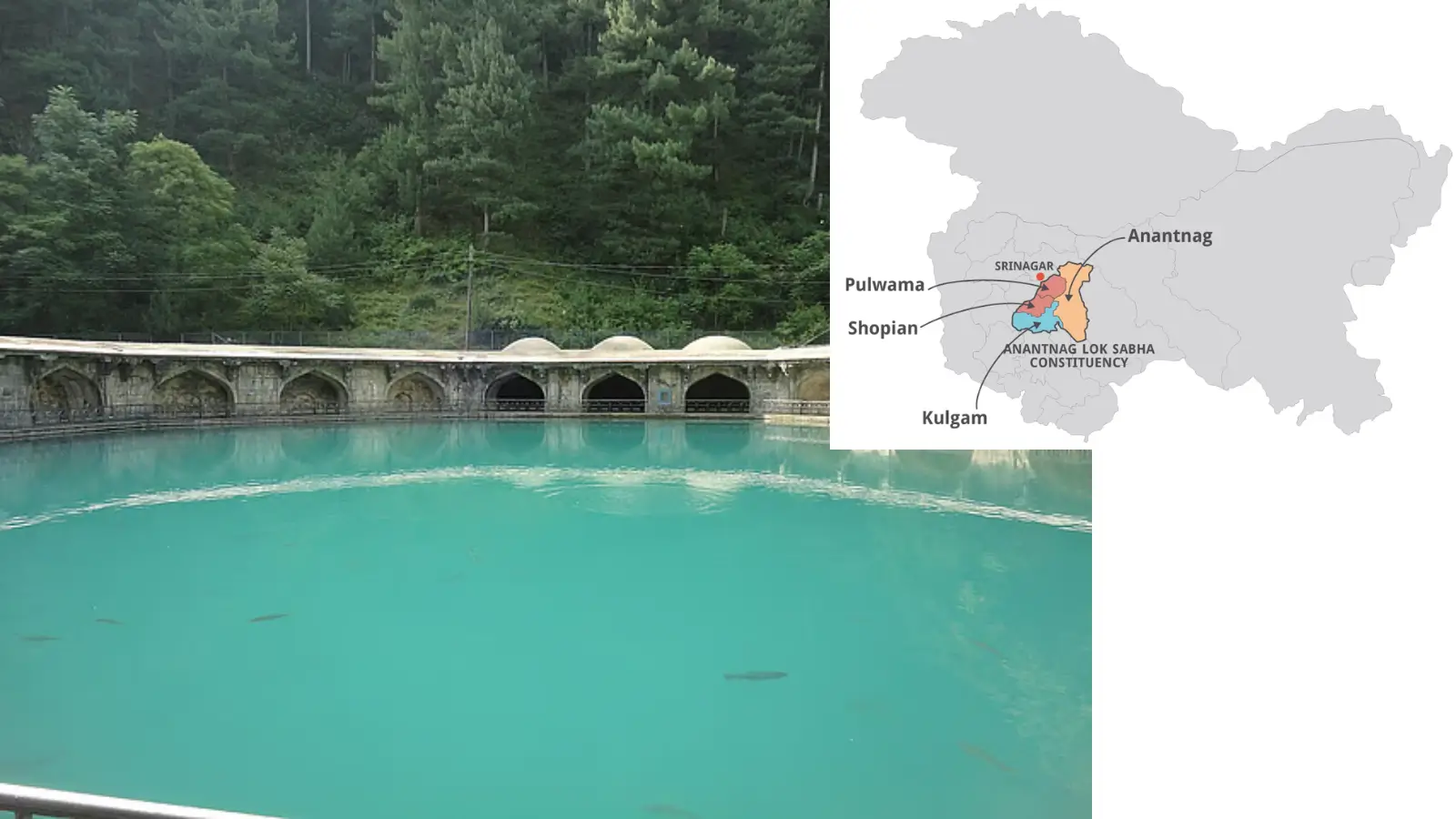
The Jhelum River originates from the Verinag Spring also known as Chashma Verinag, located in Anantnag district (80 km south of Srinagar) at the foot of the Pir Panjal Range in the southeastern part of the Kashmir Valley, Union Territory of Jammu & Kashmir. This natural spring is perennial and forms the primary headwater of the river. The name “Verinag” comes from Sanskrit words meaning “spring” and “to flow”.
 Definition: What is a spring?
Answer: A spring in a water source is a natural outlet where groundwater emerges from the earth’s surface, often from underground rock layers (aquifers) due to natural pressure, acting as a vital part of the water cycle and a key source for streams, rivers, and drinking water.
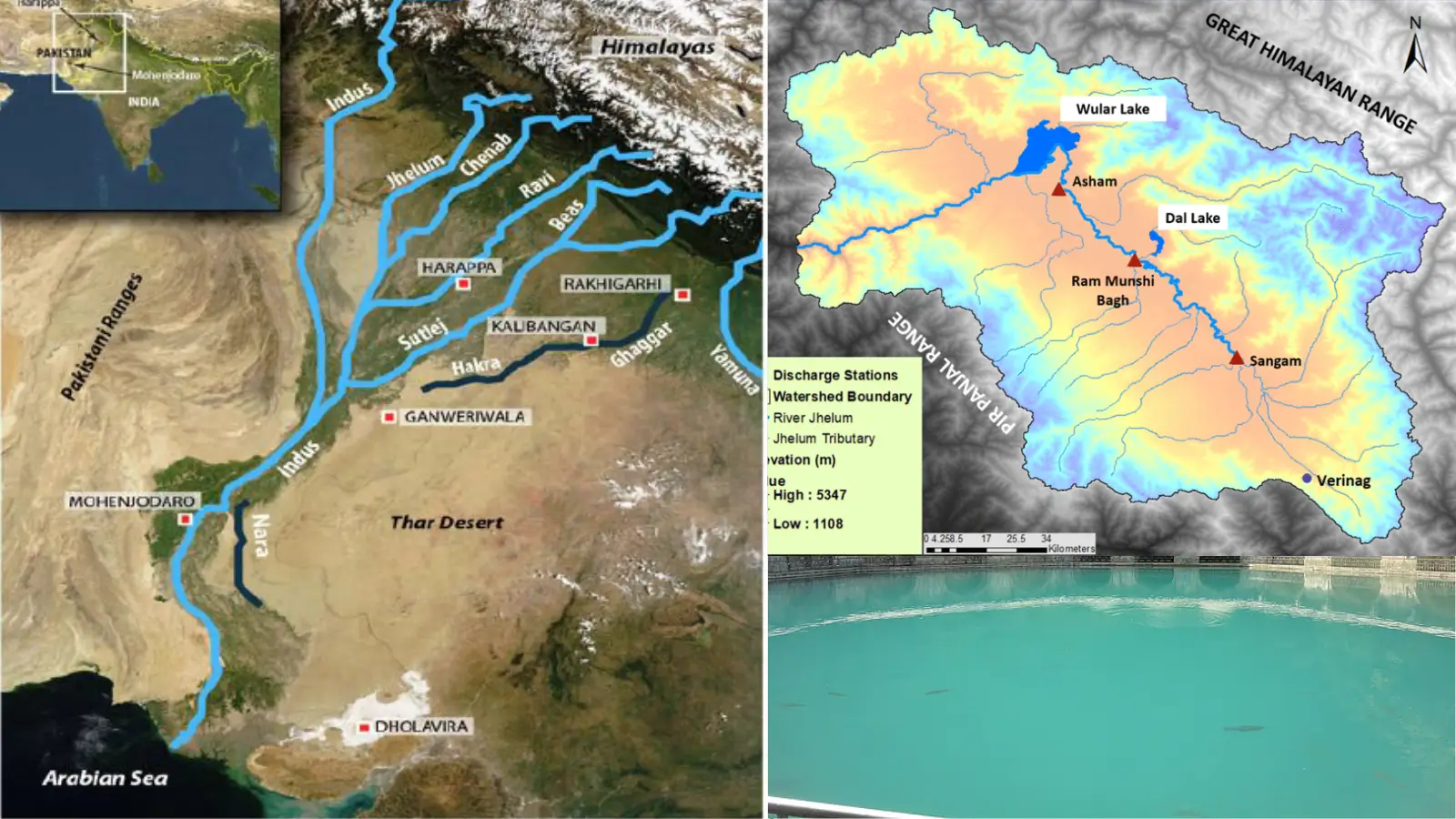
Jhelum River Map
The Jhelum River map and its linkage with the Indus River system is given below.

Jhelum River Course
The course of the Jhelum can be explained in three broad segments:
(i) Upper Course (India): From Verinag in Anantnag district, the river flows northwest through the Kashmir Valley. The river in the Valley is surrounded by mountain ranges. he Kuti and Brahmasakal are the highest peaks at 4675 mts. in elevation in the basin.
It first flows through lush valleys before entering Wular Lake near Srinagar, one of the largest freshwater lakes in Asia, which regulates the flow and acts as a natural buffer against floods.
Emerging from Wular Lake, the river crosses the Pir Panjal Range through a deep narrow gorge over 2,000–2,100 m in places.
Wular Lake is the 2nd largest fresh-water lake of Asia and largest fresh-water lake of India. It is spread in a total area of 200 square km covering almost 24 km in length while its breadth is 10 km. The main source of water for Wular Lake is River Jhelum. This lake also has a small island in its centre called the ‘Zaina Lank’. This island was constructed by King Zainul-Abi-Din. Wular Lake is also said to be a remnant of Satisar Lake that existed in ancient times.
(ii) Middle Course (India to Pakistan): After leaving the mountains, the Jhelum enters Pakistan-administered territory near Baramulla and Muzaffarabad.
Here it receives its largest tributary, the Kishanganga (Neelum) River, along with other tributaries such as Kunhar and Poonch Rivers.
The river turns southward, flowing through hills and plains towards the Punjab plains.
(iii) Lower Course (Pakistan): In Pakistan’s Punjab Province, it flows through broad alluvial plains, skirting the Salt Range. The Jhelum ultimately meets the Chenab River at Trimmu in the Jhang District, Pakistan.
The combined waters of Chenab (with Jhelum’s water) afterwards contribute to the Panjnad, which in turn joins the Indus River near Mithankot (Sindh).
Jhelum River Length and Basin
The total length of the Jhelum River is approximately 725 kilometers. However, the length of Jhelum in India up to existing ceasefire line (LoC) is about 165 Kms. It drains parts of India and Pakistan, with a significant catchment in the Kashmir Valley and adjacent hill regions.
The basin supports fertile agricultural lands, towns and cities, and its hinterland has historically sustained dense settlement.
Jhelum River Tributaries
There are number of tributaries of the Jhelum River. The largest tributary of the Jhelum is the Kishenganga (Neelum) River, which joins near Muzaffarabad and enters the Punjab province, Pakistan.
The Kunhar River is the second largest tributary of the river, which connects Pakistan-occupied Kashmir (PoK) and Pakistan on the Kohala Bridge of the Kanghan valley.
| Right-Bank Tributaries | Left-Bank Tributaries |
|---|---|
|
|
This tributary network enhances the Jhelum’s discharge and contributes to downstream irrigation and hydropower potential.
Jhelum River Mouth / Confluence
The Jhelum does not directly join the Indus. It joins the Chenab River at Trimmu in Punjab, Pakistan. The Chenab-Jhelum waters then proceed to form the Panjnad River, which ultimately flows into the Indus River near Mithankot in Sindh.
Jhelum River Dams, Barrages, Canals
India (J&K)
- Uri Dam Projects (I & II) — hydropower projects on upper Jhelum tributaries in Baramulla.
- Kishanganga Hydroelectric Plant — major power plant on the Kishanganga tributary.
Pakistan
- Mangla Dam — one of the largest earth-fill dams on the Jhelum, with huge storage and ~1,000 MW power capacity; crucial for irrigation in Punjab and Sindh.
- Rasul Barrage — important for canal irrigation off taking to agricultural lands.
- Trimmu Barrage — near the Chenab confluence; aids in irrigation/flow management.
Canals
- Upper Jhelum Canal — diverts water from Mangla towards Chenab.
- Rasul–Qadirabad Link Canal — links Jhelum to Chenab canal system.
These structures help in irrigation, flood control and hydropower generation, making the Jhelum basin economically significant.
Jhelum River Lakes and Wetlands
- Wular Lake — very important natural regulator in the Kashmir valley.
- Dal Lake, Manasbal Lake, Nigeen Lake, Anchar Lake, Khanpursar, Gil Sar, etc., are additional water bodies indirectly connected to the valley system and influence local hydrology.
Distinguishing Geographical Features of Jhelum River
- Superimposed Course: The river has a superimposed course, cutting deep gorges across the Pir Panjal, indicating ancient antecedent flow before mountain uplift.
- Transboundary River: The Jhelum forms an important transboundary river between India and Pakistan, with implications for water sharing (Indus Waters Treaty context) and regional cooperation.
- Hydrology: Discharge is largely controlled by snowmelt in the Himalayas and monsoon rains, leading to strong seasonal variation.
FAQs Associated with Jhelum River
Question: Where does the Jhelum River start and end?
Answer: The Jhelum River originates from Verinag Spring in the Pir Panjal Range of Jammu & Kashmir and ends by joining the Chenab River at Trimmu in Punjab, Pakistan.
Question: Why is the Jhelum River famous?
Answer: The Jhelum River is famous for draining the Kashmir Valley, flowing through Srinagar, forming Wular Lake, and its strategic importance under the Indus Waters Treaty
Question: Which is the largest tributary of River Jhelum?
Answer: The Kishanganga River (Neelum River) is the largest and most important tributary of the Jhelum River.
Question: Which city is located near the Jhelum River?
Answer: Srinagar, the summer capital of Jammu & Kashmir, is the major city located on the banks of the Jhelum River.
Question: Which river is longer, Jhelum or Ravi?
Answer: The Jhelum River is longer (about 725 km) than the Ravi River (about 720 km).
Question: Which lake is formed by the Jhelum River?
Answer: The Wular Lake, one of the largest freshwater lakes in Asia, is formed by the Jhelum River in Jammu & Kashmir.
Question: Which river originates in a spring at Verinag?
Answer: The Jhelum River originates from the Verinag Spring in the Anantnag district of Jammu & Kashmir.
Sources and References
Factual information is compiled from standard geography textbooks and official government sources. Interpretations and explanations are original.
- Read this article to understand basic terminology associated with the drainage system and river system.
- NCERT Class XI — India: Physical Environment
- Document on Jhelum River by Water Resource Information System (WRIS) of Ministry of Jal Shakti