
The Tapti River is a major west-flowing river of Peninsular India and the second longest of its kind after the Narmada. The official name is the Tapti River, though it is also commonly known as the Tapi River. Flowing through the states of Madhya Pradesh, Maharashtra, and Gujarat, the river plays a significant role in shaping the physical landscape, agriculture, economy, and settlement patterns of western India. Owing to its structural origin and rift-valley-like course, the Tapti is often studied alongside the Narmada in Indian geomorphology.
The Tapti River is often referred to as the “twin” or “handmaid” of the Narmada due to their parallel courses and similar physiographic characteristics. The Tapti is one of only three long rivers in peninsular India that flow from east to west, the others being the Narmada River and the Mahi River.
Source or the Origin of Tapti River
The Tapti River originates near Multai forests in the Betul district of Madhya Pradesh, at an elevation of approximately 752 metres above sea level. Its source lies in the eastern Satpura Range of southern Madhya Pradesh.
Structural Control of the River
The Tapti River flows westward through a fault-controlled trough, broadly parallel to the Narmada. Although not a classic rift valley river in the strict geological sense, its course is structurally guided, reflecting tectonic weaknesses in the Peninsular block. This makes the Tapti an important example of structural rivers in India.
Course of the Tapti River
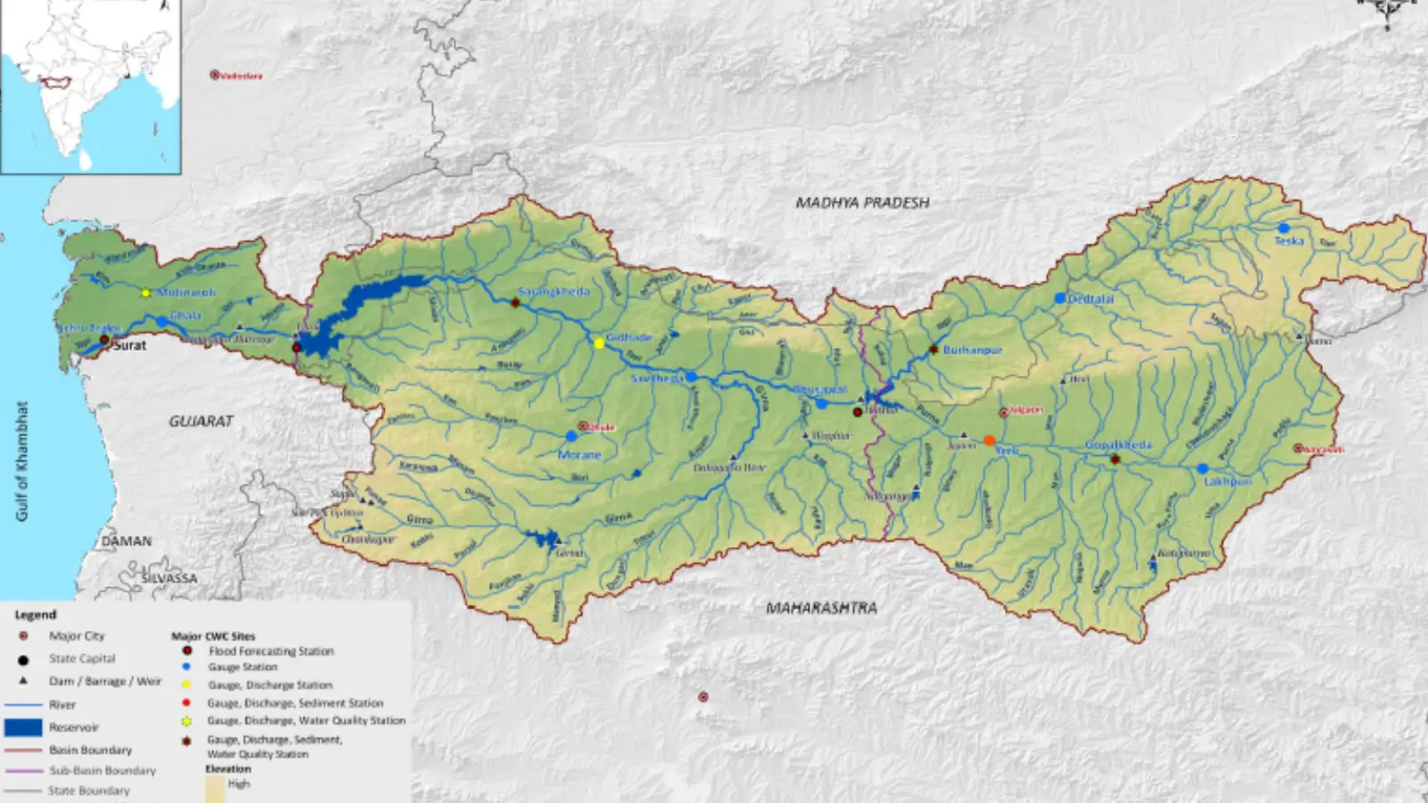
From its origin, the Tapti River flows westward for a total length of about 724 km, traversing the states of Madhya Pradesh, Maharashtra, and Gujarat, before emptying into the Gulf of Khambhat (Cambay), an inlet of the Arabian Sea.
- Total length of Tapti River: approximately 724 km
- Drainage basin area: about 65,145 sq km
The basin extends across the Satpura ranges, Deccan Plateau, and coastal plains of Gujarat, showing significant physiographic diversity.
Drainage Pattern: The Tapti basin exhibits a dendritic drainage pattern, indicating relatively homogeneous rock structure in much of the basin. However, localized structural control influences tributary alignment in certain stretches.
Upper Course (Madhya Pradesh)
In its upper course, the Tapti flows through narrow valleys and steep gradients, resulting in:
- Rapid flow velocity
- Limited floodplain development
- High erosional activity during monsoon months
For the first 282 km, the river flows through Madhya Pradesh, of which 54 km forms the inter-state boundary with Maharashtra. It drains the historic Nimar region, which has long been associated with fertile alluvial soils and agricultural activity.
Important towns and features along its course in Madhya Pradesh include:
- Multai – the source of the river
- Nepanagar – an industrial town in Burhanpur district, known for the National Newsprint and Paper Mills (established in 1956)
- Burhanpur – a historically significant city
- Satpura Tiger Reserve / Satpura National Park, located near the river basin
Middle Course (Maharashtra)
After leaving Madhya Pradesh, the Tapti enters northern Maharashtra, flowing for about 228 km across the Vidarbha and Khandesh regions in the north-western part of the Deccan Plateau. In this stretch, the river drains a large portion of the historic Khandesh region, supporting extensive agricultural activity. The river supports crops such as banana, cotton, sugarcane, and pulses.
In Maharashtra, the river flows across the north-western Deccan Plateau, particularly the Khandesh region. Here, the gradient decreases, leading to:
- Wider valleys
- Increased lateral erosion
- Development of alluvial plains suitable for agriculture
Important urban and regional centres influenced by the Tapti basin include:
- Jalgaon – popularly known as the “Banana City” due to banana cultivation
- Dhule and Nandurbar districts
- The Melghat Tiger Reserve (Gugamal National Park) lies near the northern boundary of the Tapti basin, with the Satpura ranges and river system forming part of its ecological boundary.
Lower Course (Gujarat)
After exiting Maharashtra, the Tapti flows across southern Gujarat, where it traverses a broad alluvial plain and gradually widens. In this region, the river is extensively used for irrigation, industry, and urban water supply.
In Gujarat, the Tapti enters a broad alluvial plain, marked by:
- Meandering channels
- Deposition of fine sediments
- Extensive irrigation networks
Dams and Major Projects
Ukai Dam (Vallabh Sagar) – a major multipurpose earth-cum-masonry dam located near Ukai, approximately 94 km upstream of Surat. It serves purposes of irrigation, flood control, and hydroelectric power generation (installed capacity of about 300 MW).
Major Cities and Towns
- Vyara – district headquarters of Tapi district (located near, but not directly on, the river)
- Surat – a major metropolitan city on the lower course of the Tapti, known for its textile and diamond industries
- Bardoli and Bharuch – towns within the broader basin influence
Tapti River Mouth and Tidal Influence
The Tapti River experiences tidal influence for approximately 30–50 km upstream from its mouth, extending up to the Singanapore Weir. The river finally empties into the Gulf of Khambhat (Cambay) near Dumas Beach along the Gujarat coast.
Tributaries
The Tapti River has a well-developed drainage system with 14 major tributaries, each exceeding 50 km in length.
Right-bank tributaries (4):
- Vaki
- Gomai
- Arunavati
- Aner
Left-bank tributaries (10):
- Nesu
- Buray
- Panjhra (Panzara)
- Bori
- Girna
- Waghur
- Purna
- Mona
- Sipna
- Amravati
The left-bank drainage system is more extensive than that of the right bank, owing to the regional slope and physiographic conditions of the basin.
Climate and Hydrology
Rainfall Regime: The Tapti basin lies within the tropical monsoon climatic zone and receives most of its rainfall from the south-west monsoon (June–September).
- Upper basin: 900–1,200 mm
- Lower basin: 700–900 mm
Seasonal Flow: The Tapti is a seasonal river, with:
- High discharge during monsoon months
- Reduced flow in the dry season
Flooding is common in the lower course, especially around Surat, necessitating flood-control measures.
Soils and Natural Vegetation
Soil Types:
- Black cotton soils (Regur) dominate the middle basin
- Alluvial soils occur extensively in the lower basin
- Red and lateritic soils are found in upland areas
Natural Vegetation: The basin originally supported tropical dry deciduous forests, particularly teak and bamboo. However, much of the natural vegetation has been cleared for agriculture and urban development.
Human Use and Economic Importance
Agriculture: The Tapti basin supports intensive agriculture, with major crops including:
- Cotton
- Banana
- Sugarcane
- Pulses and oilseeds
Irrigation is facilitated by canals and reservoirs, particularly in Gujarat and Maharashtra.
Urban and Industrial Development
Major urban centres such as Surat have grown along the Tapti due to:
- Reliable water supply
- Transport advantages
- Industrial development (textiles, diamonds)
River Valley Projects
Ukai Dam (Vallabh Sagar): The Ukai Dam, located in Gujarat, is a major multipurpose project that provides:
- Irrigation
- Flood control
- Hydroelectric power (approximately 300 MW)
While beneficial, the project has also led to displacement of tribal populations and ecological concerns.
Environmental Issues and Challenges
Floods: Frequent flooding in the lower basin, particularly in Surat, has resulted in:
- Loss of life and property
- Urban planning challenges
- Pollution
Industrial and domestic effluents have degraded water quality in urban stretches.
- Ecological Degradation
- Reduction in forest cover
- Siltation of reservoirs
- Decline in aquatic biodiversity
Tidal Influence and Estuarine Characteristics: The Tapti experiences tidal influence for 30–50 km upstream from its mouth. The estuary is characterized by:
- High tidal range
- Saline water intrusion
- Mangrove vegetation in patches
Sources and References
Factual information is compiled from standard geography textbooks and official government sources. Interpretations and explanations are original.
- Read this article to understand basic terminology associated with the drainage system and river system.
- Geological Survey of India — Tectonic evolution of the Narmada rift system
- Central Water Commission — Narmada River basin profile
- NCERT Class XI — India: Physical Environment
- Document of Tapti River by India- Water Resource Information System (WRIS) of Ministry of Jal Shakti