The Indus River is one of the oldest and most significant rivers of Asia and forms the backbone of the Indus River System, which drains large parts of South Asia. It is not only a major physical feature but also the cradle of the Indus Valley Civilisation, one of the world’s earliest urban cultures. Geographically, historically, and geopolitically, the Indus occupies a central place in the understanding of the Indian subcontinent.
In the Rigveda, the Indus River is referred to as Sindhu, meaning “a large flowing river.”
Also read: Rigvedic, Ancient, and Greek Names of Rivers of the Indus Valley System
![]() Indian Geography: Indian Drainage System
Indian Geography: Indian Drainage System
This article is part of Indian Drainage System. To get complete information, please read associated articles.
Indus River Map
The Indus River map is given below. Source is mapsofindia.com
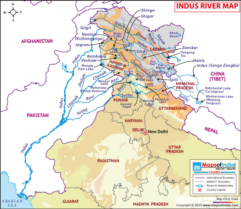
Indus river map. Source: https://www.mapsofindia.com/maps/rivers-between-india-and-pakistan.html
Indus River Origin / Source
The Indus River originates in the high-altitude region of the Tibetan Plateau, near the sacred Mount Kailash, in the Tibet Autonomous Region of China. Its source lies close to Lake Manasarovar, one of the highest freshwater lakes in the world, at an elevation of approximately 5,100 metres above mean sea level.
The river rises from glacial meltwaters, particularly from the Bokhar Chu glacier, which provides a perennial supply of water and gives the Indus a strong glacio-nival regime. Although the Indus flows in the vicinity of both Lake Manasarovar and Lake Rakshastal, it does not directly originate from either lake.
Source: Near Lake Manasarovar, close to the Bokhar Chu glacier
Elevation: About 5,100 metres above sea level
From its source region, the Indus initially flows northwestward across the cold and arid landscape of the Tibetan Plateau, where it is known locally as Singi Khamban, meaning the “Lion’s Mouth.” The river’s early course is characterised by wide valleys, braided channels, and limited vegetation due to the rain-shadow effect of the surrounding mountain ranges.
The location of its origin outside the political boundaries of India makes the Indus a transboundary river, enhancing its strategic and geopolitical significance in South Asia. The high-altitude, tectonically active source region also explains the river’s deep incision and powerful erosional capacity as it later enters the Himalayan and trans-Himalayan mountain systems.
 Did You Know?
In Tibet, the Indus River is known by names like Sengge Zangbo, Sengge Khabab, or Senge Tsangpo, all meaning “Lion River” or “Lion’s Mouth,” referencing its origin near Mount Kailash. It’s called Singi Khamban (Lion’s Mouth) in some contexts and is also known as the source stream, Shiquan He (Lion River) in Chinese.
Indus River Course
The course of the Indus River is conventionally divided into three distinct parts—upper, middle, and lower courses—based on physiography, gradient, and dominant fluvial processes. Throughout its long journey, the river traverses some of the world’s highest mountain systems before flowing across extensive alluvial plains.
(i) Upper Course (Source Region to Leh Region): The upper course of the Indus River begins near Mount Kailash on the Tibetan Plateau, where the river rises from glacial meltwaters associated with the Bokhar Chu glacier. In this region, the river flows northwestward through a high-altitude, cold desert environment marked by sparse vegetation and extreme climatic conditions. The channel here is wide and braided, reflecting the low gradient and heavy sediment load typical of glacio-nival rivers.
As the Indus enters Indian territory in the Ladakh region of the Union Territory of Ladakh, it flows between the Karakoram Range to the north and the Zanskar Range to the south. The river cuts deep gorges and narrow valleys, demonstrating its antecedent character, as it maintained its course during the uplift of the Himalayas. Important tributaries such as the Zanskar River join the Indus in this stretch, significantly increasing its discharge. The river flows past Leh, forming the core of human settlement and irrigation in the otherwise arid Ladakh region.
(ii) Middle Course (Ladakh to Punjab Plains): The middle course of the Indus River extends from the Ladakh region into Pakistan, where the river enters through Gilgit-Baltistan. In this stretch, the Indus flows through some of the world’s most rugged and tectonically active terrain, carving spectacular deep gorges across the Karakoram, Hindu Kush, and western Himalayan ranges. The river’s gradient remains steep, and erosional activity dominates.
This section is marked by the confluence of several major tributaries, including the Shyok, Gilgit, Hunza, and Kabul rivers, which contribute large volumes of water derived from glaciers and snowfields. The Indus also passes near major mountain passes indirectly influencing its basin, such as the Khyber Pass, through its tributary the Kabul River. Hydroelectric projects like the Tarbela Dam, one of the largest earth-filled dams in the world, are located in this course, highlighting its importance for energy generation and water regulation.
(iii) Lower Course (Punjab Plains to the Arabian Sea): The lower course of the Indus River begins as the river enters the Punjab and Sindh plains of Pakistan, where the gradient decreases sharply and depositional processes become dominant. The river spreads across a wide alluvial floodplain, forming extensive meanders, levees, and flood basins. This section supports dense population and intensive agriculture, sustained by one of the world’s largest canal irrigation networks.
In the lower course, the Indus receives the combined waters of its eastern tributaries—Jhelum, Chenab, Ravi, Beas, and Sutlej—through the Panchnad system, significantly increasing its volume. Near its mouth, the river divides into multiple distributaries, forming the Indus Delta, a large and ecologically significant deltaic region. Finally, the Indus empties into the Arabian Sea, south of Karachi, marking the completion of its long journey from the Tibetan Plateau to the sea.
Indus River Length and Drainage Basin
The Indus River is one of the longest rivers in Asia, with a total length of approximately 3,180 kilometres, measured from its source near Mount Kailash on the Tibetan Plateau to its mouth at the Arabian Sea.
Of this total length, about 1,100 kilometres lie within India, mainly across the Ladakh region, while the remaining course flows through China (Tibet Autonomous Region) and Pakistan, where the river covers its longest stretch. The considerable length of the Indus reflects its origin in a high-altitude glacial environment and its extended journey across diverse physiographic regions, ranging from cold deserts and rugged mountain gorges to fertile alluvial plains.
The Indus is notable for being longer than the Ganga within the Indian subcontinent and for maintaining a perennial flow despite traversing arid and semi-arid zones.
Drainage Basin: The drainage basin of the Indus River is one of the largest river basins in the world, covering an area of approximately 1.1 million square kilometres. This vast basin extends across four countries—China, India, Afghanistan, and Pakistan, with the largest share lying within Pakistan. The basin encompasses diverse physical regions, including the Tibetan Plateau, the Himalayan, Karakoram, and Hindu Kush ranges, and the Indo-Gangetic plains. Hydrologically, the basin is dominated by glacier- and snow-fed tributaries, making it highly sensitive to climatic variations and glacier dynamics.
Indus River Tributaries and Distributaries
The Indus River system is sustained by a large number of tributaries that drain the Himalayan, Karakoram, Hindu Kush, and trans-Himalayan regions, making it one of the most complex and hydrologically significant river systems in Asia. These tributaries contribute glacial meltwater, snowmelt, and monsoonal rainfall, ensuring the perennial nature of the river. For academic clarity, the tributaries of the Indus are generally classified into right-bank (western) and left-bank (eastern) tributaries based on the direction of flow.
Right-Bank (Western) Tributaries
The right-bank tributaries of the Indus originate mainly in the Hindu Kush and western Himalayan ranges and join the Indus from the west. Among them, the Kabul River is the most significant. It rises in the Hindu Kush mountains of Afghanistan, flows eastward through Afghanistan and Pakistan, and joins the Indus near Attock. The Kabul River is strategically important due to its international character and its role in sustaining agriculture and settlements in eastern Afghanistan and north-western Pakistan.
Other important right-bank tributaries include the Shyok River, Gilgit River, Hunza River, and Kurram River. The Shyok and Hunza rivers originate from glaciated regions of the Karakoram Range, contributing large volumes of sediment and meltwater. These rivers are characterised by steep gradients, deep gorges, and high erosional capacity, reflecting the tectonically active terrain through which they flow. Collectively, the western tributaries play a crucial role in augmenting the Indus’s discharge before it enters the plains.
Left-Bank (Eastern) Tributaries
The left-bank tributaries form the eastern arm of the Indus River system and are hydrologically and economically the most important. These include the Jhelum, Chenab, Ravi, Beas, and Sutlej rivers, which originate in the Himalayan region of India. These rivers flow westward and south-westward across the Punjab plains, eventually joining the Indus either directly or through the Panchnad river system.
Among these, the Sutlej River is the longest, while the Chenab River carries the largest volume of water. The Beas and Ravi join the Sutlej, and the combined flow meets the Chenab to form the Panchnad, which later merges with the Indus. These rivers are extensively regulated by dams, barrages, and canals, forming the backbone of one of the world’s largest irrigation networks.
Distributaries of the Indus River
The distributaries of the Indus River develop mainly in its lower course, particularly in the Sindh plains of Pakistan, where the river enters a low-gradient, depositional environment. Near its mouth, the Indus splits into numerous channels, forming the extensive Indus Delta. Major distributaries include the Nara Canal, Rohri Canal, Khairpur Feeder, and Left Bank Outfall Drain, many of which have been modified or extended as part of irrigation and flood-control systems.
These distributaries play a crucial role in distributing water for agriculture, supporting deltaic ecosystems, and maintaining wetlands and mangrove forests along the coast. However, extensive upstream regulation has reduced sediment supply and freshwater flow to the delta, leading to issues such as coastal erosion, salinity ingress, and ecological degradation. The study of Indus distributaries is therefore important not only from a physical geography perspective but also in understanding human-induced changes in large river systems.
Indus River Mouth / Confluence
The Indus River ends its long course by emptying into the Arabian Sea, forming the extensive and ecologically significant Indus Delta along the Sindh coast of Pakistan. The mouth of the river lies to the south-east of Karachi, near the coastal districts of Thatta and Badin, where the river disperses into a network of distributaries before finally meeting the sea. This deltaic region marks the transition of the Indus from a fluvial to a marine environment and represents the final stage of its geomorphological evolution.
Geomorphologically, the Indus Delta is one of the largest deltas in South Asia, built primarily by the long-term deposition of fine alluvium carried from the Himalayan, Karakoram, and Tibetan highlands. Historically, the delta was highly dynamic, with shifting channels and seasonal flooding that enriched coastal soils. However, extensive upstream regulation through dams and barrages has significantly reduced sediment supply and freshwater discharge, leading to coastal erosion, shrinking deltaic area, and increased salinity intrusion.
Ecologically, the mouth of the Indus supports mangrove forests, estuarine wetlands, and diverse marine life. These mangroves, among the largest arid-climate mangrove systems in the world, play a crucial role in coastal protection, fisheries, and carbon sequestration. Reduced freshwater flow has stressed these ecosystems, making the Indus mouth a focal point in debates on river management and environmental sustainability.
Indus River Dams, Barrages, Canals
The Indus River system is one of the most heavily regulated river systems in the world. A network of large dams, barrages, and link canals has been developed primarily in Pakistan, with limited but strategic infrastructure in India (Ladakh region). These structures serve multiple purposes, including irrigation, hydroelectric power generation, flood control, and water storage, and are closely linked to the provisions of the Indus Waters Treaty (1960).
Major Dams on the Indus River
The Tarbela Dam is the most important and largest dam built on the Indus River. Located near Haripur in Khyber Pakhtunkhwa, Pakistan, downstream of the Indus–Kabul confluence, Tarbela is one of the largest earth-fill dams in the world. It plays a crucial role in hydroelectric power generation, irrigation support, and flood moderation. The dam regulates the highly seasonal flow of the Indus, which is dominated by glacial and snowmelt during summer months.
Another significant structure is the Diamer–Bhasha Dam, currently under construction on the upper Indus in Gilgit-Baltistan. Once completed, it is expected to enhance water storage capacity, reduce sediment load reaching Tarbela, and significantly boost hydropower production. The dam also has strategic importance in terms of long-term water security and flood control in downstream regions.
Smaller hydropower projects and planned dams exist along the upper Indus in the mountainous regions, primarily focused on run-of-the-river power generation, due to the steep gradient and narrow valleys.
Major Barrages on the Indus River
The barrages on the Indus River are mainly concentrated in the Sindh and Punjab plains of Pakistan, where they play a dominant role in diverting water into an extensive canal network. The Jinnah Barrage, located near Kalabagh, regulates flow for irrigation in Punjab and supports hydropower generation. It marks an important point in the transition of the Indus from its middle to lower course.
Further downstream, the Guddu Barrage, Sukkur Barrage, and Kotri (Ghulam Muhammad) Barrage are critical hydraulic structures. The Sukkur Barrage, in particular, is one of the oldest and most significant barrages on the Indus, forming the backbone of irrigation in upper Sindh. It feeds several major canals, transforming the arid plains into productive agricultural land.
The Kotri Barrage, located near Hyderabad, is the last major barrage on the Indus before it enters the deltaic region. It regulates water supply to lower Sindh and plays a role in preventing saline seawater intrusion, although reduced downstream flows have posed ecological challenges for the Indus Delta.
Dams and Infrastructure in India
In India, the Indus flows primarily through the Ladakh region, where large storage dams are limited due to rugged terrain, seismic sensitivity, and international treaty obligations. However, several small hydropower projects and barrages have been developed or proposed to meet local energy needs. These projects are typically run-of-the-river in nature and have minimal storage
FAQs Associated with Indus River
Question: Where does the Indus River originate?
Answer: The Indus River originates near Mount Kailash in the Tibetan Plateau, close to Lake Manasarovar, where it is known as the Sengge Zangbo (Lion River).
Question: In which direction does the Indus River initially flow?
Answer: The Indus River initially flows north-westward in Tibet before entering Ladakh (India), after which it turns southward and southwestward in Pakistan.
Question: Through which countries does the Indus River flow?
Answer: The Indus River flows through China (Tibet Autonomous Region), India (Ladakh), and Pakistan, where it forms the backbone of the country’s river system.
Question: What is the total length of the Indus River?
Answer: The Indus River is approximately 3,180 km long, making it one of the longest rivers in Asia. Of this total length, about 1,100 kilometres lie within India, mainly across the Ladakh region, while the remaining course flows through China (Tibet Autonomous Region) and Pakistan.
Question: Which Indian state or union territory does the Indus River flow through?
Answer: In India, the Indus River flows only through the Union Territory of Ladakh.
Question: What are the major tributaries of the Indus River?
Answer: The major tributaries of the Indus River include Jhelum, Chenab, Ravi, Beas, Sutlej, and Zanskar River. Among these, the first five are collectively known as the Punjab rivers.
Question: Which is the largest tributary of the Indus River?
Answer: The Chenab River is the largest tributary of the Indus River in terms of water discharge.
Question: Which sea does the Indus River drain into?
Answer: The Indus River drains into the Arabian Sea, forming a large delta near Karachi in Pakistan.
Question: What is the Rigvedic name of the Indus River?
Answer: In the Rigveda, the Indus River is referred to as Sindhu, meaning “a large flowing river.”
Question: What type of river is the Indus?
Answer: The Indus is a perennial river, fed by glaciers, snowmelt, and monsoon rainfall.
Sources and References
Factual information is compiled from standard geography textbooks and official government sources. Interpretations and explanations are original.
- Read this article to understand basic terminology associated with the drainage system and river system.
- NCERT Class XI — India: Physical Environment
- Document on Jhelum River by Water Resource Information System (WRIS) of Ministry of Jal Shakti