Kosi River is a transboundary river which flows through China, Nepal, and India. It is one of the largest tributaries of Ganga River. The Kosi River is also known as ‘Kaushiki’ in Sanskrit and Sapta Koshi or Saptakoshi.
Origin of Kosi River
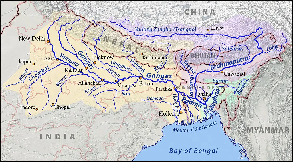
The Kosi River originates in the central Himalayas and is formed by the confluence of three principal headstreams—the Sun Kosi, Arun, and Tamur. These rivers rise in the high mountainous regions of Nepal and the Tibet Autonomous Region of China, draining extensive glaciated and snow-fed catchments. The Arun, which originates in Tibet, is the largest of the three and contributes the greatest volume of water, while the Sun Kosi and Tamur originate within Nepal.
Sapta Koshi River
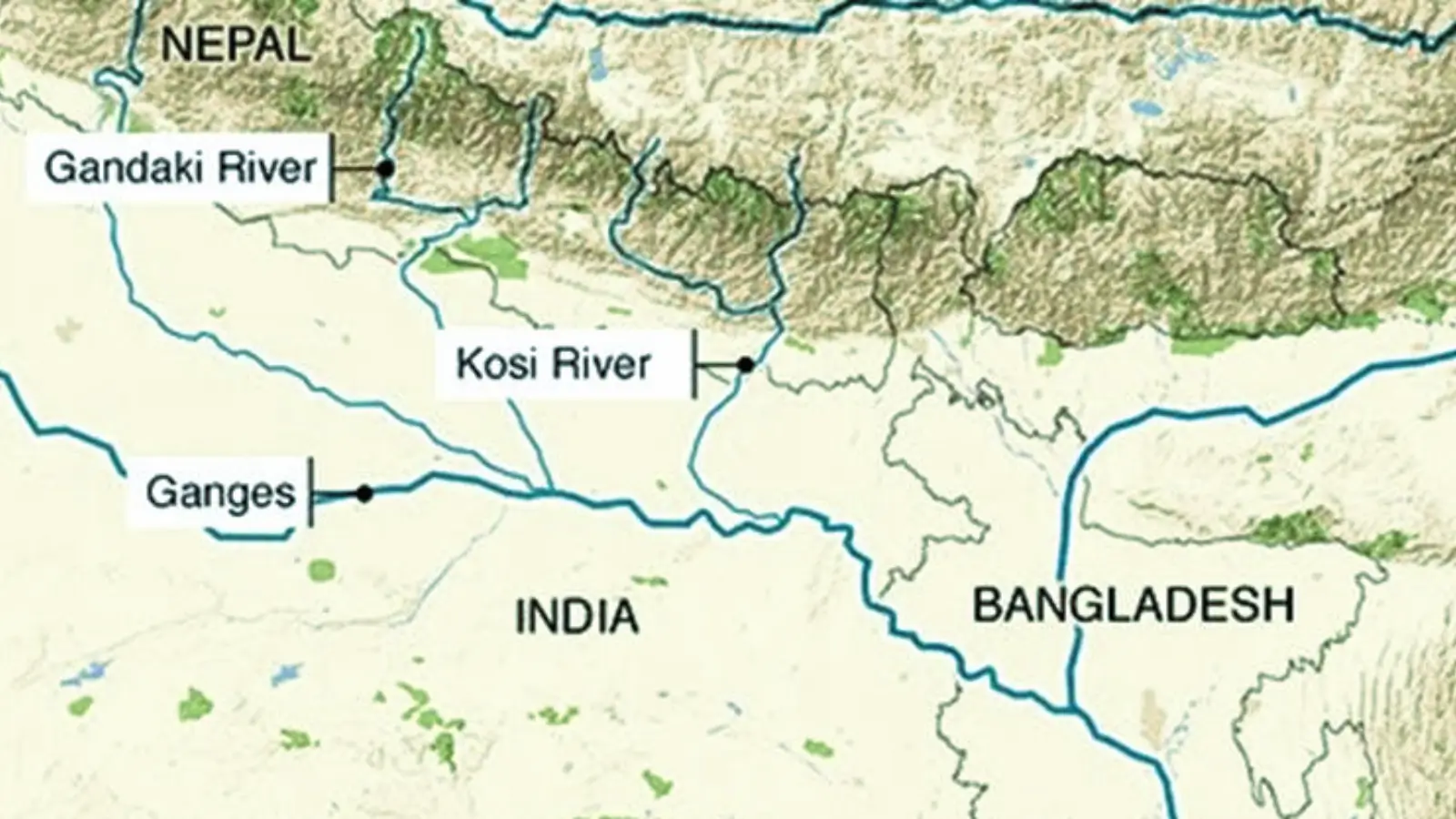
Collectively, the river system is known as the Sapta Koshi, also written as Saptakoshi, meaning “seven rivers,” because it is fed by seven major Himalayan tributaries: Sun Kosi, Arun, Tamur, Dudh Kosi, Likhu, Tama Kosi, and Indravati. These tributaries join together in eastern Nepal to form the main Kosi River. From there, the river flows southward through the plains of Nepal, cutting across the Siwalik and Terai regions, before entering India near Bhimnagar in Supaul district of Bihar.
The Kosi River basin has some of the tallest mountain peaks, such as the Mount Everest, Khangchendzonga and Lhotse.
The river is antecedent to the Himalayas, which means it predates the formation of the mountain range and maintained its course even as the Himalayas began to rise, gradually cutting deeper into the uplifting terrain.
Course of the Kosi River in India
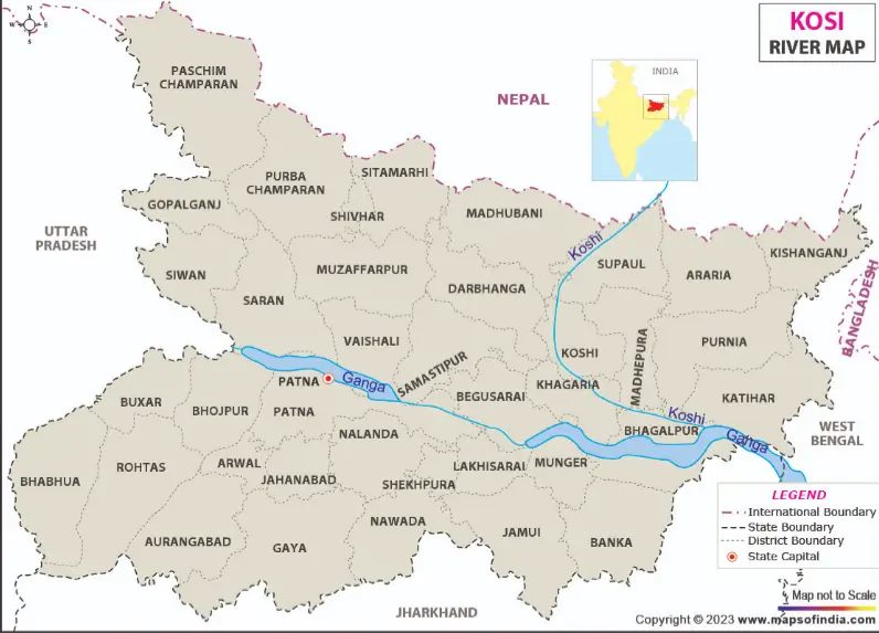
After entering India near Bhimnagar in Supaul district of Bihar, the Kosi River begins its course across the vast alluvial plains of north Bihar. From Bhimnagar, the river flows in a generally southward direction through the districts of Supaul, Saharsa, Madhepura, Khagaria, and Katihar.
Sorrow of Bihar
Historically, the Kosi has shifted its course westward by more than 100 km over the past two centuries, affecting large areas of northern Bihar. Because of these unpredictable changes and recurring floods, it has earned the name “Sorrow of Bihar.”
The Kosi alluvial fan is one of the largest in the world. It measures 180 km long and 150 km wide. An alluvial fan is a fan-shaped deposit of sand, gravel, and other sediments formed when a river or stream flows out of a narrow mountain valley onto a flat plain and spreads out, slowing down and dropping the material it carries.
Map source and copyright: https://www.mapsofindia.com/bihar/koshi-river-changes-course.html
Tributaries
Kamala and Bagmati Rivers are the major tributaries of Kosi River in India.
Confluence
In its lower course, the river gradually stabilizes and flows southeastward. Finally, the Kosi joins the Ganga River near Kursela in Katihar district, completing its journey through India.
Length
From its origin until its confluence with Ganga River, Kosi River flows for about 720 km.
Kosi Barrage
The Kosi Barrage, also known as the Bhimnagar Barrage, was constructed between 1959 and 1963 across the Kosi River near the India–Nepal border. It was built under a joint agreement between India and Nepal for irrigation, flood control, and hydropower generation. However, the entire cost of constructing the project was borne by India.
Protected Areas
Two major protected areas lie along the Kosi River system in Nepal: Koshi Tappu Wildlife Reserve and Sagarmatha National Park. Koshi Tappu, established in 1976 in the eastern Terai, is a Ramsar-listed wetland.
Sagarmatha National Park, opened in 1976 and recognized as a UNESCO World Heritage Site, covers the Everest region of eastern Nepal. It includes Mount Everest and several other peaks.