Basis for the Classification of Indian Drainage System
The Indian drainage system can be grouped in different ways to better understand the nature and behaviour of its rivers. Broadly, it is classified under three main criteria:
- Based on the source of origin of rivers – where and how the rivers begin.
- Based on the drainage pattern – the manner in which rivers and their tributaries flow and form networks.
- Based on the direction of flow towards the sea – whether rivers flow eastward or westward before emptying into the sea.
Each of these classifications helps in understanding India’s physical geography, river systems, and their role in shaping landforms and supporting human activities.
1. Classification of Rivers based on source of origin of rivers
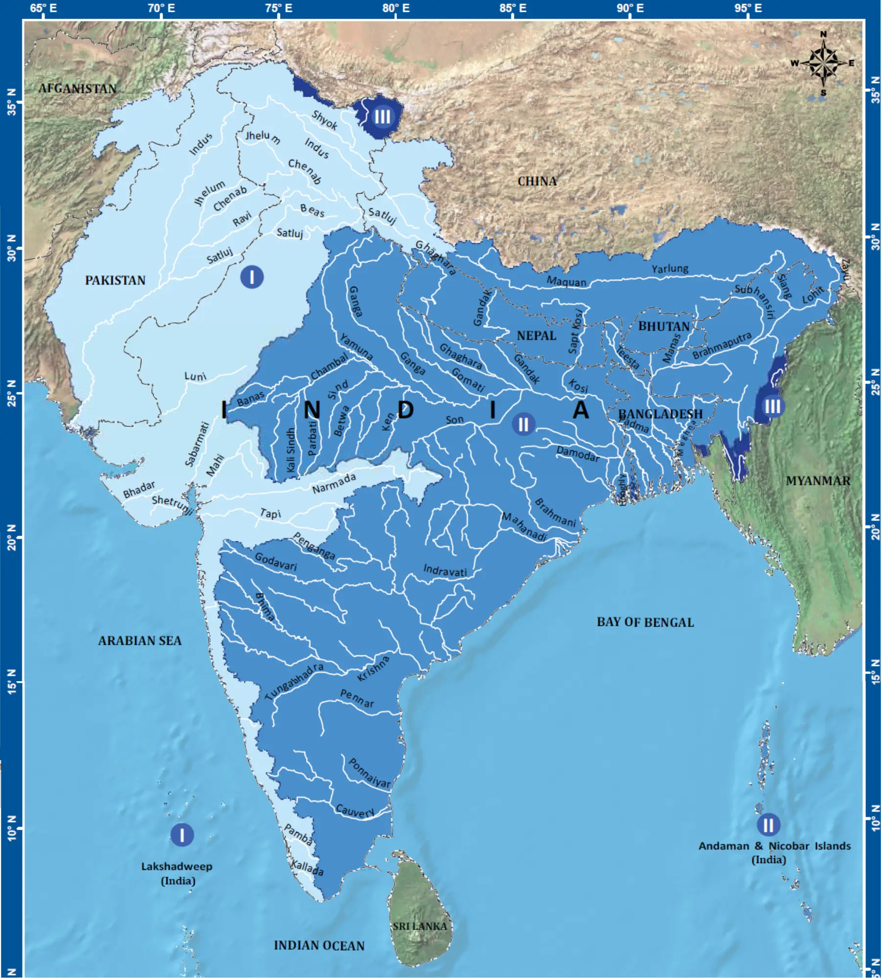
On the basis of their source regions (source of origin), Indian rivers are broadly classified into Himalayan Rivers and Peninsular Rivers. This classification is significant as the origin of a river largely determines its flow regime, erosional capacity, and geomorphological role.
(i) Himalayan Rivers: Himalayan rivers originate from the high-altitude Himalayan mountain system, mainly from glaciers and snowfields (Glacial Origin). They are perennial in nature, as their discharge is sustained by both snowmelt and monsoonal rainfall. These rivers have long courses, high sediment load, and strong erosional power in their upper reaches, while in the plains they form extensive floodplains and deltas. Major examples include the Indus, Ganga, and Brahmaputra river systems.
(ii) Peninsular Rivers: Peninsular rivers arise from the ancient Peninsular Plateau and are predominantly rain-fed (Monsoon-dependent). As a result, they exhibit a seasonal flow pattern. These rivers generally have shorter courses, fixed channels, and relatively lower erosional capacity due to the stable geological structure of the plateau. Important peninsular rivers include the Godavari, Krishna, Cauvery, Narmada, and Tapi.
In geography, “perennial” river means river that last throughout the year, flowing continuously or growing year after year, unlike seasonal ones. While “non-perennial” river mean river that doesn’t flow year-round, have significantly reduced flow during dry seasons and only flowing during periods of sufficient rainfall, often from monsoons or heavy rain. These are also called ephemeral, which means short bursts after rain, and season rivers or intermittent rivers.
2. Classification of Rivers Based on Drainage Pattern
Drainage pattern refers to the spatial arrangement of river channels and their tributaries within a drainage basin. It is largely controlled by geological structure, lithology (rock type), slope, and tectonic history of a region. On this basis, rivers are classified into the following major drainage patterns:
(i) Dendritic Drainage Pattern: This pattern resembles the branching of a tree (dendron = tree). It develops over homogeneous rocks with uniform resistance to erosion and gentle slopes. It indicates structural simplicity and absence of major tectonic control. Example: Rivers of the Northern Plains.
(ii) Trellis Drainage Pattern: In this pattern, the main river flows in a straight course, while tributaries join it at near right angles. It develops in regions of alternating hard and soft rock strata, especially in folded or tilted terrains. Example: Parts of the Himalayan foothills.
(iii) Radial Drainage Pattern: Rivers flow outward in all directions from a central highland or dome-shaped structure. This pattern is associated with volcanic cones or structural uplands. Example: Streams around the Amarkantak Plateau.
(iv) Rectangular Drainage Pattern: This pattern is characterized by sharp bends and right-angled turns in river courses. It develops in areas with jointed or faulted rock structures, where rivers follow lines of weakness. Example: Parts of the Peninsular Plateau.
(v) Annular Drainage Pattern: Rivers flow in concentric circular paths around a structural dome or basin. This pattern develops where hard and soft rocks are arranged in circular or dome-like forms. Example: Limited occurrences in structurally complex regions.
3. Classification of Rivers Based on Direction of Flow towards the Sea
The direction of river flow towards the sea (orientation of flow) is an important basis for classifying rivers, as it reflects the structural slope, relief features, and tectonic framework of a region. In India, rivers are broadly classified into east-flowing and west-flowing rivers on this basis.
(i) East-Flowing Rivers: East-flowing rivers originate mainly from the Peninsular Plateau and flow towards the Bay of Bengal. These rivers are generally longer in length and have gentle gradients, which favour extensive lateral erosion and deposition. As a result, most east-flowing rivers form large deltas at their mouths.
Major east-flowing rivers include the Mahanadi, Godavari, Krishna, and Cauvery. Collectively, they drain a larger area of the Indian subcontinent.
(ii) West-Flowing Rivers: West-flowing rivers flow towards the Arabian Sea and are generally shorter in length due to the steep western slope of the Peninsular Plateau and the narrow Western Coastal Plain. These rivers have steeper gradients, high flow velocity, and limited depositional activity. Consequently, they usually form estuaries rather than deltas.
Important west-flowing rivers include the Narmada, Tapi, Periyar, and Sabarmati.
Classification of Indian Drainage System as per Textbooks
On the basis of physiographic origin, drainage characteristics, and basin behaviour, Indian rivers are classified into four major groups:
- Himalayan Rivers,
- Deccan (Peninsular) Rivers,
- Coastal Rivers, and
- Rivers of Inland Drainage Basin.
This classification reflects India’s diverse relief features, climatic controls, and tectonic framework.
1. Himalayan Rivers
Basis of Classification: Rivers originating from the Himalayan mountain system, including glaciated and high-rainfall regions.
Basic Features: Himalayan rivers are mostly perennial, as they are fed by glacial melt and monsoonal rainfall. They have long courses, high discharge, and carry heavy alluvial sediment load. These rivers actively erode in their upper reaches and deposit sediments in the plains, forming fertile floodplains and extensive deltas. Their courses are often marked by meanders, ox-bow lakes, and braided channels.
Major Rivers / River Systems:
- Indus River System (Indus, Jhelum, Chenab, Ravi, Beas, Sutlej)
- Ganga River System (Ganga, Yamuna, Ghaghara, Gandak, Kosi)
- Brahmaputra River System
2. Deccan (Peninsular) Rivers
Basis of Classification: Rivers originating from the Peninsular Plateau, composed of ancient crystalline rocks.
Basic Features: Deccan rivers are primarily rain-fed (monsoon dependent) and therefore show seasonal flow patterns. They generally have shorter courses, fixed channels, and comparatively lower erosional capacity due to the tectonic stability of the plateau. Most east-flowing rivers form deltas, while west-flowing ones usually form estuaries.
Major Rivers / River Systems:
- East-flowing: Mahanadi, Godavari, Krishna, Cauvery
- West-flowing: Narmada, Tapi, Sabarmati
3. Coastal Rivers
Basis of Classification: Short rivers originating near the coastal margins, especially along the Western and Eastern Coastal Plains.
Basic Features: Coastal rivers are generally short in length with small drainage basins. They have steep gradients, swift flow, and are mostly rain-fed, responding quickly to monsoonal rainfall. Due to their short course, they have limited erosional and depositional features but play an important role in local water supply and coastal ecology.
Major Rivers:
- West Coast: Periyar, Bharathapuzha, Sharavathi, Mandovi, Zuari
- East Coast: Subarnarekha, Vamsadhara, Pennar (shorter rivers)
4. Rivers of the Inland Drainage Basin
Basis of Classification: Rivers that do not reach the sea and drain into lakes, salt flats, or disappear in arid regions.
Basic Features: These rivers are found mainly in arid and semi-arid regions with low rainfall and high evaporation. They are mostly ephemeral and lose water through infiltration and evaporation. Such rivers reflect internal drainage (Endorheic basins) rather than external drainage.
Major Rivers:
- Luni River (disappears into the Rann of Kachchh)
- Streams draining into Sambhar Lake and other inland salt lakes of Rajasthan
Significance of This Classification
This four-fold classification provides a comprehensive understanding of India’s drainage diversity, helps in river basin planning, water resource management, and explains variations in agriculture, settlement patterns, and geomorphological processes across the country.
NCERT Geography Books and Other Sources
Students and aspirants are also advised to refer to the sources mentioned below.
- Must read basic concepts of drainage system and river systems
- NCERT Geography Book of Class 9, Chapter 3: Drainage
- NCERT Geography Book of Class 11, Chapter 3: Drainage System
- Article on Major River System in India created by India- Water Resource Information System (WRIS) by Ministry of Jal Shakti