The Sutlej River is the longest river of the Indus River System that flows partly through India. It plays a crucial role in the physical geography, water resources, agriculture, hydropower generation, and geopolitics of the north-western Indian subcontinent.
In the Rigveda, the Sutlej River is referred to as Shatadru, while ancient Greek accounts mention it as Zaradros (or Hesidrus).
Also read: Rigvedic, Ancient, and Greek Names of Rivers of the Indus Valley System
![]() Indian Geography: Indian Drainage System
Indian Geography: Indian Drainage System
This article is part of Indian Drainage System. To get complete information, please read associated articles.
Sutlej River Origin / Source
The Sutlej River originates from Lake Rakshastal, a high-altitude saline lake situated near Mount Kailash on the Tibetan Plateau in the Tibet Autonomous Region of China, at an elevation of approximately 4,575 metres above sea level. The source region lies in a cold, arid, trans-Himalayan environment characterized by sparse vegetation and glacial landforms.
From its origin, the river initially flows in a north-westerly direction across the Tibetan Plateau before turning south-westwards and entering Indian territory through the Shipki La Pass in Himachal Pradesh. The Sutlej is classified as an antecedent river, as it maintained its course while cutting across major Himalayan ranges during the uplift of the Himalayas, resulting in the formation of deep gorges.
Its origin outside India and its transboundary nature make the Sutlej geopolitically significant, particularly in the context of the Indus Waters Treaty (1960) and water-resource management in South Asia.
Sutlej River Map
The Sutlej River map and its linkage with the Indus River system is given below.

Sutlej River Course
(i) Upper Course (Tibetan and Himalayan Region): The upper course of the Sutlej River lies in the Tibetan Plateau and the higher Himalayan region. The river originates from Lake Rakshastal near Mount Kailash in Tibet and initially flows through a cold, arid landscape characterised by sparse vegetation and broad valleys. In this stretch, the Sutlej exhibits braided channels and carries large volumes of meltwater derived from glaciers and seasonal snow.
After crossing into India through the Shipki La Pass in Kinnaur district of Himachal Pradesh, the river cuts across the Greater Himalayas, forming deep gorges and narrow valleys. The steep gradient and confined channel result in strong vertical erosion, giving the river a distinctly youthful character.
(ii) Middle Course (Himachal Pradesh): In its middle course, the Sutlej flows through the mountainous terrain of Himachal Pradesh, passing districts such as Kinnaur, Shimla, and Bilaspur. The river valley gradually widens, and although the river remains swift-flowing, the intensity of vertical erosion decreases. Major tributaries like the Spiti and Baspa join the Sutlej in this stretch, significantly increasing its discharge.
This part of the river has been extensively harnessed for hydroelectric power generation, with major projects such as Nathpa Jhakri, Karcham Wangtoo, and Kol Dam regulating its flow. The river here shows a transition from purely erosional to mixed erosional–transportational processes.
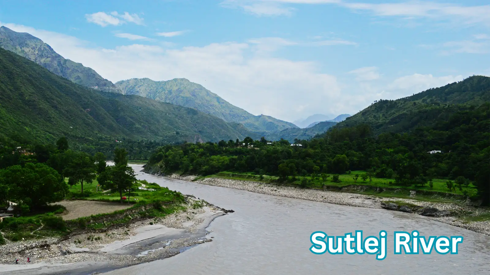
(iii) Lower Course (Punjab Plains): The lower course of the Sutlej River begins after the river emerges from the Shivalik foothills near Rupnagar (Ropar) and enters the alluvial plains of Punjab. In this stretch, the river gradient becomes very gentle, and the Sutlej develops wide meanders, floodplains, and depositional features typical of a mature to old-stage river. The river is heavily channelised and diverted through an extensive network of canals, supporting irrigation in Punjab, Haryana, and Rajasthan.
Flowing westward into Pakistan, the Sutlej finally joins the Chenab River as part of the Panchnad system, and its waters ultimately reach the Indus River before draining into the Arabian Sea.
Sutlej River Length and Drainage Basin
Length of the Sutlej River: The Sutlej River has a total length of approximately 1,450 kilometres, making it the longest tributary of the Indus River system. Of this, about 1,050 kilometres lie within Indian territory, while the remaining course flows through China (Tibet) and Pakistan.
The river’s considerable length reflects its origin in the trans-Himalayan region and its long journey across diverse physiographic units, including the Tibetan Plateau, the Himalayan mountain system, and the Indo-Gangetic plains. Despite its transboundary nature, the Sutlej is classified as an Eastern River under the Indus Waters Treaty (1960), and its waters are allocated for exclusive use by India.
Total length: Approximately 1,450 kilometres
Length in India: Around 1,050 kilometres
It is the longest tributary of the Indus River and the easternmost major river of the Indus system.
Drainage basin area: Approximately 395,000 sq km (entire basin).
The basin spans China (Tibet), India, and Pakistan
Drainage Basin of the Sutlej River: The drainage basin of the Sutlej River covers an extensive area of approximately 395,000 square kilometres, spread across China (Tibet Autonomous Region), India, and Pakistan. The basin encompasses a wide range of physiographic regions, including the cold arid Tibetan Plateau, the Greater and Lesser Himalayas, the Shivalik foothills, and the fertile alluvial plains of north-western India and Pakistan.
In the mountainous upper basin, drainage is largely structurally controlled, with deep gorges and steep slopes, while in the plains the river exhibits a dendritic drainage pattern marked by meanders and floodplains. The Sutlej basin supports dense human population, extensive irrigation networks, and major hydropower projects, making it one of the most economically significant and intensively managed river basins within the Indus system.
Sutlej River Tributaries
Tributaries of the Sutlej River: The Sutlej River is fed by several important Himalayan and sub-Himalayan tributaries, which contribute significantly to its discharge, sediment load, and hydrological regime.
In its upper and middle courses, major left-bank tributaries such as the Spiti River and the Baspa River join the Sutlej in Himachal Pradesh. The Spiti River, originating in the cold desert region of Himachal Pradesh, is the largest tributary and drains a vast high-altitude basin characterised by glacial meltwater and seasonal flow variations.
The Baspa River, flowing through the Baspa Valley, adds substantial perennial flow and enhances the river’s hydropower potential. Other smaller tributaries, including the Nogli and Gambhar rivers, also contribute in the Himalayan stretch.
From the right bank, the Beas River joins the Sutlej at the Harike Wetland in Punjab, making it the most important tributary in the plains and significantly increasing the volume of water carried by the Sutlej.
Distributaries of the Sutlej River: In its lower course across the alluvial plains of Punjab, the Sutlej gives rise to a well-developed network of distributaries and canals, largely man-made, which are used for irrigation and water management. Prominent among these are the Sirhind Canal, Bikaner Canal, and the Rajasthan Feeder Canal, which divert Sutlej waters to support agriculture in Punjab, Haryana, and Rajasthan.
The Indira Gandhi Canal, though originating from the Sutlej–Beas system, represents a major inter-basin transfer that extends the river’s influence into the arid regions of western Rajasthan. These distributaries have transformed the Sutlej into one of the most intensively regulated rivers in India, playing a decisive role in the Green Revolution
Sutlej River Mouth / Confluence
The Sutlej River completes its independent course in Pakistan, where it confluences with the Chenab River to form part of the Panchnad river system. This confluence takes place in the Punjab plains of Pakistan, downstream of the Indo–Pakistan border, in a region characterised by a very gentle gradient and dominant depositional processes. At this stage, the Sutlej carries a large volume of regulated flow, much of it derived from upstream Himalayan meltwater and controlled releases from dams and canals in India.
After joining the Chenab, the combined waters flow south-westward and ultimately merge with the Indus River, which drains into the Arabian Sea.
Unlike the Beas, which joins the Sutlej in India, the Sutlej’s final confluence with Chenab occurs outside India, making it geopolitically significant.
Sutlej River Dams, Barrages, Canals
The Sutlej River is one of the most intensively regulated rivers of the Indus River System, owing to its immense potential for hydropower generation, irrigation, and flood control. Its steep gradient in the Himalayan region and large, perennial discharge have led to the construction of several major dams and barrages, particularly in Himachal Pradesh and Punjab, making the river central to India’s post-Independence river-valley development strategy.
In its upper and middle courses in Himachal Pradesh, the Sutlej hosts some of India’s most important hydroelectric projects. The Nathpa Jhakri Dam, located in Kinnaur district, is one of the largest underground hydropower projects in the country and utilises the river’s high velocity and steep relief. Downstream of this, projects such as the Karcham Wangtoo Hydroelectric Project, Rampur Hydroelectric Project, and Kol Dam further harness the river’s energy. These projects are primarily run-of-the-river schemes, designed to generate electricity while minimising large-scale submergence, though they have significantly altered the river’s natural flow regime.
The most prominent structure on the Sutlej is the Bhakra Dam, located near the border of Himachal Pradesh and Punjab. It is a massive concrete gravity dam and one of the highest of its kind in the world. The dam has created the Gobind Sagar Reservoir, which serves multiple purposes, including irrigation, hydroelectric power generation, flood moderation, and drinking water supply. The Bhakra–Nangal Project, of which Bhakra Dam is the core component, has played a transformative role in the Green Revolution, especially in Punjab, Haryana, and western Uttar Pradesh.
In the lower course across the Punjab plains, the Sutlej is further controlled by a series of barrages and headworks that facilitate water diversion into extensive canal networks. Structures such as the Ropar (Rupnagar) Headworks regulate the river’s flow and enable controlled distribution of water for irrigation. These barrages reduce flood risk during the monsoon while ensuring year-round water supply to agricultural fields.
The Sutlej supports one of the most extensive canal systems in India, making it a backbone of irrigated agriculture in north-western India. Major canals originating from the Sutlej system include the Sirhind Canal, which irrigates large areas of central and southern Punjab, and the Bikaner Canal, which carries water towards the semi-arid regions of Rajasthan. The Rajasthan Feeder Canal and the Indira Gandhi Canal, drawing water from the Sutlej–Beas system, represent major inter-basin water transfer projects that have transformed the Thar Desert into cultivable land.
Overall, the network of dams, barrages, and canals on the Sutlej River has converted it from a predominantly natural Himalayan river into a highly managed water system. While these structures have ensured energy security, agricultural productivity, and regional development, they have also raised concerns related to sediment trapping, ecological disruption, and downstream flow reduction.
FAQs Associated with Sutlej River
Question: Where does the Sutlej River originate?
Answer: The Sutlej River originates from Lake Rakshastal, a high-altitude saline lake located near Mount Kailash on the Tibetan Plateau in China, at an elevation of about 4,575 metres above sea level. It is a trans-Himalayan antecedent river, cutting across major Himalayan ranges.
Question: Is the Sutlej River part of the Indus River System?
Answer: Yes, the Sutlej River is a major river of the Indus River System. It is the longest tributary of the Indus, and after joining the Chenab River in Pakistan, its waters ultimately flow into the Indus River and drain into the Arabian Sea.
Question: Which countries does the Sutlej River flow through?
Answer: The Sutlej River flows through three countries: China (Tibet Autonomous Region), India (Himachal Pradesh and Punjab), and Pakistan. This transboundary nature makes it geopolitically significant.
Question: What is the total length of the Sutlej River?
Answer: The total length of the Sutlej River is approximately 1,450 kilometres, of which around 1,050 kilometres lie within India. It is the longest river of the Indus system flowing partly through India.
Question: Which river does the Sutlej join?
Answer: The Sutlej River joins the Chenab River in Pakistan, forming part of the Panchnad river system. The combined waters then merge with the Indus River.
Question: Which are the major tributaries of the Sutlej River?
Answer: Major tributaries of the Sutlej River include the Spiti River, Baspa River, Nogli, Gambhar, and the Beas River. Among these, the Spiti River is the largest Himalayan tributary, while the Beas River is the most important plains tributary.
Question: What are the major dams built on the Sutlej River?
Answer: Important dams on the Sutlej River include: Bhakra Dam (forming Gobind Sagar Reservoir), Nathpa Jhakri Dam, Karcham Wangtoo Project, Rampur Hydroelectric Project, Kol Dam. These dams support hydropower generation, irrigation, and flood control.
Question: What is the Bhakra–Nangal Project?
Answer: The Bhakra–Nangal Project is a multipurpose river valley project built on the Sutlej River. Its main structure, the Bhakra Dam, supplies irrigation water to Punjab, Haryana, and Rajasthan, generates hydroelectric power, and helps control floods.
Question: Why is the Sutlej River important for irrigation?
Answer: The Sutlej River supports extensive canal irrigation systems such as the Sirhind Canal, Bikaner Canal, Rajasthan Feeder Canal, and Indira Gandhi Canal. These canals have transformed large parts of north-western India into productive agricultural regions.
Question: What is the Sutlej–Beas link?
Answer: The Sutlej–Beas link is an inter-basin water transfer system in which water from the Beas River is diverted into the Sutlej to support irrigation and hydropower generation, especially in Punjab and Rajasthan.
Question: What is the ancient name of the Sutlej River?
Answer: In ancient Indian texts, the Sutlej River was known as Shatadru. Greek historians referred to it as Zaradros or Hesidrus.
Question: What are the major environmental issues associated with the Sutlej River?
Answer: Major concerns include glacier retreat, sedimentation in reservoirs, landslides and floods in the Himalayan region, and ecological disruption due to dams and reduced downstream flow.
Sources and References
Factual information is compiled from standard geography textbooks and official government sources. Interpretations and explanations are original.
- Read this article to understand basic terminology associated with the drainage system and river system.
- NCERT Class XI — India: Physical Environment
- Document on Jhelum River by Water Resource Information System (WRIS) of Ministry of Jal Shakti