
The Narmada River is one of India’s most important west-flowing peninsular rivers, rising in the Maikala Range (Amarkantak Plateau) in eastern Madhya Pradesh and draining into the Arabian Sea through the Gulf of Khambhat near Bharuch, Gujarat after an approximate course of 1,310–1,312 km. It is unique among Indian rivers as it flows through a rift valley between the Vindhya and Satpura ranges — a geologically significant feature.
The three longest rivers in peninsular India that flows from east to west are the Narmada River, Tapti River and Mahi River, in the order.
Narmada River Origin or Source
The Narmada River originates from the Narmada Kunda at Amarkantak, in Anuppur district of Madhya Pradesh. Amarkantak is located at the meeting point of the Vindhyanchal and Satpura mountain ranges, with the Maikala Hills at the center. Amarkantak is also the source of the Son River. The Narmada River originates at an elevation of about 1,048–1,057 meters above mean sea level.
The 2nd-century Greek geographer Ptolemy referred to this river as Namade. The Narmada is also known by other names, including Rewa, Amarja, Mekalkanya, Rudrakanya, and Vriddh Ganga.
Narmada River Route or Course
From Amarkantak, the river first meanders over rocky terrain, flows through a rift valley, and descends through waterfalls such as the Kapildhara Falls, and flows westward through central India.
After originating from the source, the Narmada enters a rift valley and creates scenic features like the Marble Rocks Gorge and Dhuandhar Falls near Jabalpur.
The Narmada River travels through
- Madhya Pradesh (1,077 km),
- Maharashtra (74 km), including along the border between Madhya Pradesh and Maharashtra (39 km),
- then the border between Maharashtra and Gujarat (74 km), and
- finally Gujarat (161 km)
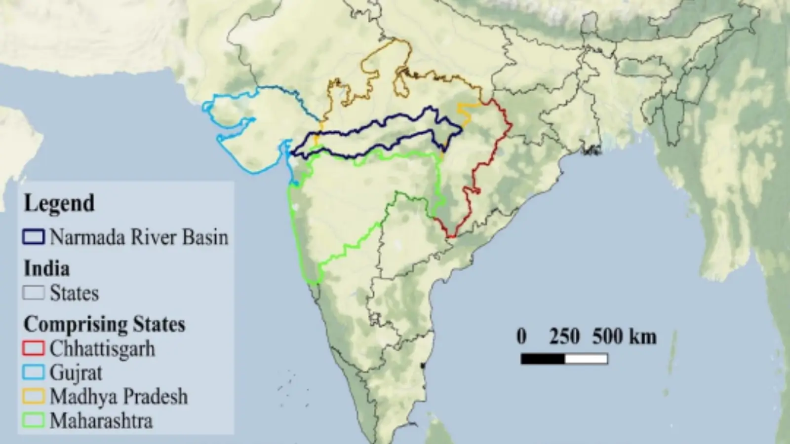
The basin spreads broadly over 40 districts, comprising 27 districts of Madhya Pradesh, seven districts
of Gujarat, four districts of Chhattisgarh, and two districts of Maharashtra.
The river flows through Madhya Pradesh, Maharashtra, and Gujarat through the Vindhya and Satpura ranges before merging into the Arabian Sea at the Gulf of Khambhat, 10 km north of Bharuch in Gujarat.
Narmada River Mouth
After travelling for about 1,312 km west from its source, the Narmada River meets the Arabian Sea at the Gulf of Khambhat via a wide estuary. The Gulf of Khambhat lies 10 km north of Bharuch in Gujarat.
Narmada River Tributaries
The Narmada has numerous tributaries joining from both banks:
Left-bank tributaries
- Tawa (major)
- Burhner
- Banjar
- Sher
- Shakkar
- Dudhi
- Ganjal
- Kundi
- Goi
- Karjan
Right-bank tributaries
- Hiran
- Tendoni
- Barna
- Kolar
- Man
- Uri
- Hatni
- Orsang
This complex tributary network supports irrigation and catchment hydrology across the basin.
Narmada River Basin Characteristics
- River Length: About 1,310–1,312 km
- Overall, it is the 5th largest river in India.
- It is the largest west-flowing river of India.
- River Basin Area: About 98,000–99,000 sq. km, covering Madhya Pradesh, Gujarat, Maharashtra, and Chhattisgarh.
- Drainage Pattern: Unlike most Indian rivers flowing into the Bay of Bengal, the Narmada’s basin is oriented horizontally and forms a rift valley — a depression created by movements of the Earth’s crust.
Physical and Cultural Features
Geological Significance: The river flowing through a rift valley makes it geologically distinctive compared to other peninsular rivers that flow over flat plateau surfaces.
Scenic and Cultural Sites
- Marble Rocks & Dhuandhar Falls near Jabalpur — major geographical and tourist attractions.
- Omkareshwar and Maheshwar — religious and cultural centres on the river banks draw pilgrims.
The river also holds religious reverence and has been mentioned in ancient Indian texts and folklore, reflecting its longstanding cultural importance.
Economic Importance
Irrigation: The Narmada basin supports vast agricultural tracts producing wheat, soybean, pulses, cotton, and sugarcane. Irrigation systems stemming from major projects have significantly enhanced water availability in arid zones.
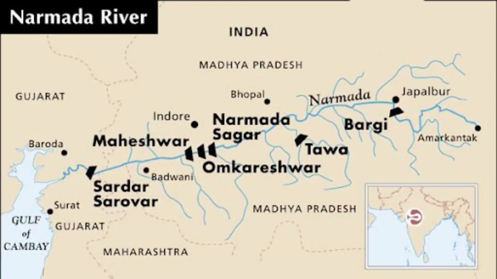
Hydropower: Major dams like:
- Sardar Sarovar Dam (Gujarat) — multipurpose dam with power, irrigation, and drinking water benefits.
- Indira Sagar Dam (Madhya Pradesh) — significant hydroelectric generation capacity.
- Omkareshwar, Bargi, Maheshwar Dams — also contribute to irrigation, power, and water management.
Drinking Water & Canal Systems
The Narmada Canal extends from the Sardar Sarovar project into Gujarat and parts of Rajasthan, alleviating water stress and aiding in drinking water supply to drought-prone regions.
Environmental and Social Issues
Narmada Bachao Andolan: The Narmada Bachao Andolan (NBA) was a major socio-environmental movement opposing large dam constructions without adequate rehabilitation for displaced communities. It attracted national attention in the 1980s–90s for highlighting issues around displacement, resettlement, and environmental protection.
Ecological Concerns: Submergence of forests and agricultural land
- Loss of biodiversity and disruption of aquatic ecosystems
- Sedimentation and changes in natural silt flow downstream
- Pollution and deforestation in the catchment area hamper ecological balance.
Strategic and Policy Dimensions
Inter-State Water Disputes: The Narmada Basin has been a subject of water sharing disputes among states (Madhya Pradesh, Gujarat, Maharashtra, Rajasthan). This led to the Narmada Water Disputes Tribunal and establishment of the Narmada Control Authority (NCA) to regulate water use and project implementation.
Role in National Water Policy: The river’s development exemplifies India’s approach to multipurpose river projects aimed at enhancing rural livelihoods, power generation, irrigation, and urban water supply.
National Parks in the Narmada River Basin
The basin has several conservation areas like the Kanha National Park, known for its diverse wildlife,
including tigers and various ungulates; Satpura National Park, which features species like the sloth bear, black buck, and flying squirrel, Mandla Plant Fossils National Park; which preserves fossilised plants dating back millions of years, providing insights into prehistoric life and past climatic condition, Pachmarhi Biosphere Reserve and Shoolpaneshwar Sanctuary Covers, supporting a wide range of plant, birds and animal species typical of the central highland region.
Sources and References
Factual information is compiled from standard geography textbooks and official government sources. Interpretations and explanations are original.
- Read this article to understand basic terminology associated with the drainage system and river system.
- Geological Survey of India — Tectonic evolution of the Narmada rift system
- Central Water Commission — Narmada River basin profile
- NCERT Class XI — India: Physical Environment
- Narmada Control Authority website
- India- Water Resource Information System (WRIS) by Ministry of Jal Shakti
- IIT Gandhinagar Study on Narmada River
Frequently Asked Questions (FAQs) on the Narmada River
Where does the Narmada River start and end?
The Narmada River originates from the Narmada Kund at Amarkantak in the Maikala Range of Madhya Pradesh. It ends (empties) into the Arabian Sea through the Gulf of Khambhat, near Bharuch in Gujarat.
Why is the Narmada River famous?
The Narmada River is famous for several reasons: It is one of the longest west-flowing rivers of India It flows through a rift valley between the Vindhya and Satpura ranges Home to major multipurpose projects like the Sardar Sarovar Dam Associated with the Narmada Bachao Andolan Has great religious significance; pilgrims perform Narmada Parikrama Features scenic spots like Marble Rocks and Dhuandhar Falls
Which states does the Narmada River flow through?
The Narmada River flows through: Madhya Pradesh Maharashtra (forms part of the boundary) Gujarat Its basin also covers parts of Chhattisgarh.
How long is the Narmada River?
The total length of the Narmada River is approximately 1,312 km, making it the longest west-flowing river in Peninsular India.
Into which sea does the Narmada River drain?
The Narmada River drains into the Arabian Sea, forming an estuary (not a delta).
Why does the Narmada form an estuary and not a delta?
Because: It flows through a steep gradient Carries less silt compared to east-flowing rivers Faces strong tidal action from the Arabian Sea Hence, it forms an estuary, not a delta.
What is the geological significance of the Narmada River?
The Narmada flows through a rift valley, which is rare among Indian rivers. It runs between two major mountain ranges: Vindhya Range (north) Satpura Range (south)
Is the Narmada River navigable?
Yes, the lower stretch of the river is partially navigable for about 100–110 km from its mouth.
What is the importance of the Narmada River for irrigation and power?
The river: Provides irrigation to drought-prone regions of Gujarat, MP, and Rajasthan Generates hydroelectric power Supplies drinking water to urban and rural areas
Which major dams are built on the Narmada River?
Some of the major dams on the Narmada River are: Sardar Sarovar Dam (Gujarat) – the largest and most famous Indira Sagar Dam (Madhya Pradesh) Omkareshwar Dam Bargi Dam Maheshwar Dam These dams are part of the Narmada Valley Development Project (NVDP).
PYQs and MCQs Related to Narmada River
Question 1. Which of the following rivers flows through a rift valley?
(a) Narmada
(b) Krishna
(c) Kaveri
(d) Godavari
Correct Answer: (a) Narmada
Explanation: The Narmada flows through a rift valley between the Vindhya and Satpura ranges — a rare geological phenomenon for Indian rivers.
The main Indian peninsular rivers flowing through rift valleys are the Narmada (largest west-flowing) and the Tapti (Tapi), both carving paths between the Vindhyan and Satpura ranges due to tectonic faulting. The Mahi River also flows through a rift valley, though between different ranges, while the Damodar River in Eastern India also follows a rift course, defying the general east-flow of most peninsular rivers.
Question 2. Consider the following statements regarding the Narmada River:
1. It rises near the Amarkantak plateau of the Vindhya Range.
2. It flows through only four states.
3. It is the only river in peninsular India that runs from east to west.
4. It does not form a delta.
How many statements are correct?
(a) Only one
(b) Only two
(c) Only three
(d) All four
Correct Answer: (a) Only one
Explanation:
- Statement 1 is not exactly correct — the river rises near Amarkantak on the Maikala Range, not the main Vindhya Range.
- Statement 2 is incorrect — it flows through three states (Madhya Pradesh, Maharashtra, Gujarat).
- Statement 3 is incorrect — it is one of two major west-flowing peninsular rivers (along with the Tapi).
- Statement 4 is correct — the Narmada forms an estuary, not a delta, due to its westward flow and steep gradient.
Question 3. With reference to the Narmada River, which of the following statements are correct?
1. It is the largest west-flowing river of the peninsular region.
2. It flows through a rift valley between the Satpura and Vindhya ranges.
3. Sardar Sarovar dam is a major hydroelectric project on the Narmada.
How many statements are correct?
(a) 1 and 2 only
(b) 2 and 3 only
(c) 1 and 3 only
(d) All of the above
Correct Answer: (c) 1 and 3 only
Explanation:
- Statement 1 is correct — the Narmada is the largest west-flowing peninsular river.
- Statement 2 is partly misleading — while it does flow in a rift valley, this valley lies between the Vindhya (north) and Satpura (south) ranges (the order given in the statement may be interpreted incorrectly depending on phrasing).
- Statement 3 is correct — Sardar Sarovar Dam is a key multipurpose project on the Narmada.
Question 4. Which river originates from the Amarkantak Plateau?
(a) Narmada
(b) Tapti
(c) Krishna
(d) Godavari
Correct Answer: (a) Narmada
Explanation: The Narmada River originates near Amarkantak on the Maikala Range.
Question 5. Which of the following rivers is also known as “Vriddh (Old) Ganga”?
(a) Narmada
(b) Yamuna
(c) Krishna
(d) Saraswati
Correct Answer: (a) Narmada
Explanation: In general knowledge resources, the Narmada is sometimes referred to as “Vriddh Ganga” for its cultural and historical significance.