Concept of Drainage Patterns
Drainage patterns refer to the configuration or plan of river channels as seen on a map or satellite image. It expresses how streams branch, join, or diverge within a drainage basin. Drainage patterns are shaped over long periods as rivers adjust their courses to zones of weakness such as joints, faults, folds, and variations in rock resistance.
While climate and slope influence the intensity of drainage development, it is the structural control exerted by bedrock characteristics that largely determines the pattern a drainage system adopts.
Structural Control of Drainage
Structural control refers to the influence of tectonic structures and rock arrangements on river courses. Rivers tend to follow paths of least resistance, which are often created by fractures, bedding planes, or fault lines. In regions where geological structures are pronounced, drainage patterns closely mirror the orientation and nature of these structures.
Structural control operates through:
- Faults and fractures, which guide linear river courses,
- Folds, which influence drainage alignment along anticlines and synclines,
- Lithological contrasts, where softer rocks are eroded more rapidly than harder ones.
Understanding these controls is essential for interpreting drainage anomalies and reconstructing geomorphic evolution.
Major Drainage Patterns and Their Structural Significance
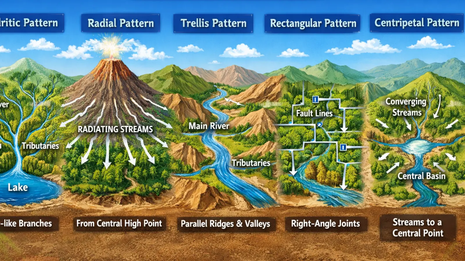
Dendritic Drainage Pattern
The dendritic pattern resembles the branching of a tree, with tributaries joining the main stream at acute angles. This pattern develops in regions where the underlying rock is uniform in resistance and structure, such as horizontal sedimentary beds or massive igneous rocks.
The absence of strong structural control allows streams to evolve freely, making dendritic drainage an indicator of geological homogeneity. Many river systems in the Indo-Gangetic plains and peninsular plateaus exhibit this pattern.
Trellis Drainage Pattern
Trellis drainage is characterised by long, parallel main streams joined by short tributaries at nearly right angles. This pattern is strongly associated with folded terrain, where alternating bands of resistant and less resistant rock exist.
Main streams occupy synclinal valleys or zones of weaker rock, while tributaries cut through resistant ridges. The trellis pattern thus reflects structural alignment and differential erosion, commonly observed in regions with folded sedimentary rocks.
Rectangular Drainage Pattern
In rectangular drainage, streams exhibit sharp bends and join at near-right angles. This pattern develops in areas where bedrock is heavily jointed or faulted, creating a network of orthogonal weaknesses.
Rivers exploit these fractures, resulting in angular channel geometry. Rectangular drainage is a clear indicator of tectonic influence and is often associated with crystalline rocks such as granite and gneiss.
Radial Drainage Pattern
Radial drainage consists of streams flowing outward in all directions from a central elevated point. It typically develops around volcanic cones, domes, or isolated hills.
The structural control here is exerted by a central uplift, from which the slope radiates outward. Radial drainage is commonly observed around volcanic features and residual hills.
Centripetal Drainage Pattern
Centripetal drainage is the reverse of radial drainage, with streams converging towards a central depression such as a basin or crater. Structural or topographic depression acts as the controlling factor.
This pattern often develops in inland basins, arid regions, or tectonic depressions where internal drainage dominates.
Annular Drainage Pattern
Annular drainage displays concentric circular or semi-circular channel patterns. It develops in regions with domal or basin-like structures, where alternating bands of resistant and weaker rocks are exposed in rings.
Rivers follow these structural rings, producing an annular arrangement. This pattern provides strong evidence of structural doming or subsidence followed by erosion.
Parallel Drainage Pattern
Parallel drainage is marked by closely spaced, nearly parallel streams flowing in the same direction. This pattern forms on uniformly steep slopes or elongated landforms.
Although slope plays a major role, structural control is evident where bedding planes or faults align the streams in a common direction.
Drainage Anomalies and Structural Interpretation
Drainage patterns also help identify drainage anomalies, such as:
- Sudden changes in river direction,
- Abandoned channels,
- River capture or diversion.
Such anomalies often indicate tectonic uplift, faulting, or tilting of the land surface. In this sense, drainage analysis becomes a diagnostic tool for understanding active or past tectonic processes.
Importance of Drainage Patterns in Geographical Analysis
The study of drainage patterns has practical and academic significance. It aids in:
- Geological mapping and mineral exploration,
- Groundwater assessment,
- Flood management and river planning,
- Interpretation of landscape evolution.
Must Read Articles Associated with this Topic
This article is part of a series of articles that clear basic concepts of the drainage system and the river system. Students and aspirants are also advised to refer to the articles mentioned below.
- Drainage System & River System
- River Source & River Mouth
- Three Stages of River
- Three Processes of Rivers — Erosion, Transportation, and Deposition
- River Basin, Catchment Area, and Watershed
- River Tributaries & River Distributaries
- Drainage Patterns & Structural Control
- River Rejuvenation and Associated Fluvial Landforms
NCERT Geography Books and Other Sources
Students and aspirants are also advised to refer to the sources mentioned below.
- NCERT Geography Book of Class 9, Chapter 3: Drainage
- NCERT Geography Book of Class 11, Chapter 3: Drainage System
- Article on Major River System in India created by India- Water Resource Information System (WRIS) by Ministry of Jal Shakti