This article explains the basic concepts of river rejuvenation and associated fluvial landforms.
The word “rejuvenation” in English means the process of making something feel new, fresh, or young again. In simple words, it refers to restoring energy, strength, or vitality.
The word “rejuvenation” in geography refers to the renewal of erosional power of a river due to a fall in base level or tectonic uplift, resulting in active vertical erosion. Thus, river rejuvenation can be defined as:
- River rejuvenation:
- is the renewal of a river’s erosional activity, especially vertical (downward) erosion, caused by an increase in its gradient or energy due to a fall in base level, tectonic uplift, or increased discharge.
Concept of River Rejuvenation
River rejuvenation refers to the process by which a river regains erosive power after a period of relative stability or maturity. Rejuvenation is primarily associated with an increase in the river’s potential energy, which enables it to resume vertical erosion and modify previously formed landforms.
The key geomorphic expression of rejuvenation is the renewed downcutting of the river bed, often superimposed upon an older valley or floodplain. As a result, the river displays features characteristic of different stages of development within the same course.
Rejuvenation Occurs when the rivers speed and erosive power increases resulting in an increase in downward erosion (vertical erosion). The characteristics of a rejuvenated river include water that flows rapidly with sloping sides that create steep cuts on the valley floor.
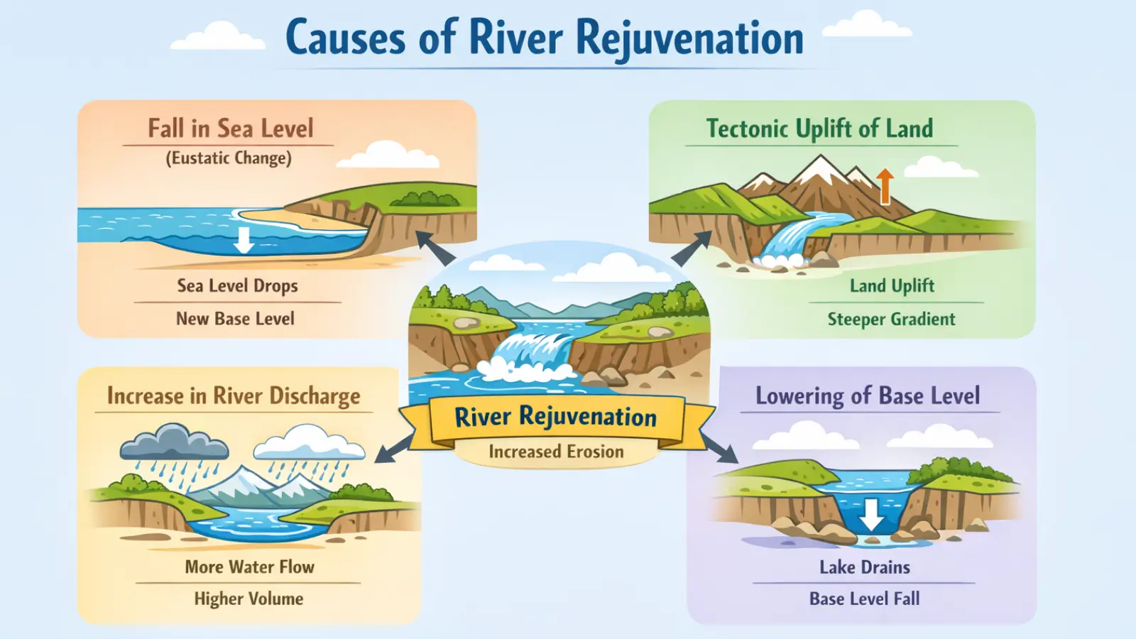
Causes of River Rejuvenation
River rejuvenation occurs when there is:
- Fall in sea level (eustatic change)
- Tectonic uplift of land
- Increase in river discharge (due to climate change, heavy rainfall, glacial melt)
- Lowering of river base level
1. Fall in Sea Level (Eustatic Change)
A fall in sea level lowers the ultimate base level of rivers that drain into the sea. As a result, the river’s longitudinal profile becomes steeper, increasing its potential energy. The river responds by intensifying vertical erosion to adjust to the new, lower base level. This renewed downcutting marks the process of river rejuvenation.
Over time, features such as river terraces and incised meanders may develop. Eustatic sea-level fall commonly occurs during glacial periods when large volumes of water are locked in ice sheets.
2. Tectonic Uplift of Land
Tectonic uplift raises the land surface without changing sea level, effectively increasing the relative height of the river above its base level. This increases the river’s gradient and velocity, enhancing its erosive power. The river begins renewed downward erosion to re-establish equilibrium. This process is known as tectonic rejuvenation.
It often leads to the formation of gorges, waterfalls, and knick points. Rivers flowing across active tectonic regions commonly show strong evidence of rejuvenation.
3. Increase in River Discharge (Climate Change / Heavy Rainfall / Glacial Melt)
An increase in river discharge raises the volume and velocity of flowing water, giving the river greater erosive capacity. Higher discharge enables the river to carry more sediment and erode its bed more effectively. This leads to renewed vertical erosion, even without a change in base level. Climate change, intensified monsoons, or glacial melting are common causes of increased discharge.
The river thus enters a rejuvenated phase, reshaping its valley. Such rejuvenation may be seasonal or long-term, depending on climatic conditions.
4. Lowering of River Base Level
The base level is the lowest level to which a river can erode, usually sea level or a lake. When this base level is lowered—due to lake drainage, river capture, or tectonic movements—the river’s equilibrium is disturbed. The river responds by cutting downward to reach the new base level. This renewed erosion signifies river rejuvenation.
Knick points often migrate upstream as erosion progresses. Eventually, the river adjusts to the new base level by forming a new graded profile.
Effects of River Rejuvenation
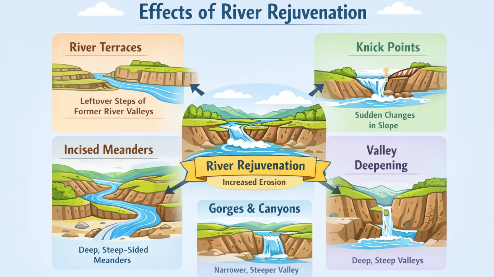
Rejuvenation leaves distinct imprints on the landscape, many of which are used by geomorphologists to reconstruct the evolutionary history of river valleys. Rejuvenation leads to:
- River terraces
- Incised meanders
- Knock points / knick points
- Valley deepening
- Gorges and canyons
1. River Terraces
River terraces are step-like flat surfaces that features along valley sides, representing former floodplain levels abandoned due to renewed downcutting. Each terrace corresponds to a phase of relative stability followed by rejuvenation. Terraces are valuable indicators of past climatic or tectonic events.
Terraces may be:
- Paired terraces, occurring at similar heights on both sides of the valley,
- Unpaired terraces, reflecting asymmetric uplift or lateral erosion.
Indian examples: Terraces along the Sutlej, Yamuna, and Alaknanda rivers.
World examples: River terraces of the Rhine (Europe) and Thames (UK).
2. Incised Meanders
Incised meanders are deep, steep-sided meanders formed when a river cuts downward instead of laterally. They develop when a mature river is rejuvenated due to tectonic uplift or fall in sea level. The river retains its meandering pattern but erodes vertically, carving deep loops. Two types are recognized: entrenched and ingrown meanders.
Indian example: Yamuna River near the Himalayan foothills.
World example: Colorado River in the Grand Canyon, USA.
3. Knick Points (Knock Points)
A knick point is a sudden break in slope along a river’s longitudinal profile. It forms where rejuvenation begins, marking the transition between old and new erosion levels. Knick points often appear as waterfalls or rapids and migrate upstream over time. They signify active adjustment of the river to a new base level.
Indian examples: Jog Falls on the Sharavathi, Dhuandhar Falls on the Narmada.
World example: Niagara Falls (USA–Canada border).
4. Valley Deepening
Rejuvenation increases a river’s vertical erosive power, causing intense downcutting of the valley floor. This process results in narrower, deeper valleys with steep sides. Lateral erosion becomes secondary during this phase. Valley deepening reflects the river’s attempt to reach a new equilibrium profile.
Indian example: Deep valleys of the Narmada and Tapi due to tectonic activity.
World example: Deep river valleys of the Andes and Rockies.
5. Gorges and Canyons
Gorges and canyons are deep, narrow valleys with very steep sides, formed due to prolonged vertical erosion after rejuvenation. A gorge is typically smaller and often formed in hard rock, while a canyon is wider and deeper, usually in horizontally layered rocks. These landforms indicate strong and sustained rejuvenation. They are classic features of youthful or rejuvenated river stages.
Indian examples: Narmada Gorge at Marble Rocks (Jabalpur), Bhagirathi gorge.
World example: Grand Canyon of the Colorado River, USA.
Rejuvenation and Valley Development
River rejuvenation introduces complexity into valley profiles. Instead of a simple progression from youth to old age, rejuvenated valleys display composite characteristics, combining features of multiple developmental stages. This challenges simplistic interpretations of river evolution and highlights the importance of external controls in shaping fluvial landscapes.
Must Read Articles Associated with this Topic
This article is part of a series of articles that clear basic concepts of the drainage system and the river system. Students and aspirants are also advised to refer to the articles mentioned below.
- Drainage System & River System
- River Source & River Mouth
- Three Stages of River
- Three Processes of Rivers — Erosion, Transportation, and Deposition
- River Basin, Catchment Area, and Watershed
- River Tributaries & River Distributaries
- Drainage Patterns & Structural Control
- River Rejuvenation and Associated Fluvial Landforms
NCERT Geography Books and Other Sources
Students and aspirants are also advised to refer to the sources mentioned below.
- NCERT Geography Book of Class 9, Chapter 3: Drainage
- NCERT Geography Book of Class 11, Chapter 3: Drainage System
- BBC Geography: Three stages of river
- Article on Major River System in India created by India- Water Resource Information System (WRIS) by Ministry of Jal Shakti