
A river is not a static geographical feature but a dynamic system that evolves as it flows from its source to its mouth. The river course refers to the entire path followed by a river, while the stages of river development describe the progressive changes in river behavior and landform creation along this course. These stages reflect variations in gradient, velocity, discharge, and dominant geomorphic processes rather than strict chronological age.
Traditionally, the river course is divided into three broad stages:
- upper course,
- middle course, and
- lower course.
Each stage is characterised by distinctive processes and landforms. Although this division is conceptual, it remains analytically useful for understanding fluvial landscapes and for addressing examination-oriented questions.
Stage 1: Upper Course (Youthful Stage)

The three stages of river – stage 1 upper course | Image source bbc.co.uk
The upper course occupies the region near the river’s source, typically in mountainous or highland areas. Here, the river flows over a steep gradient, resulting in high velocity but relatively low discharge. The channel is usually narrow, and the valley is confined.
The dominant geomorphic process in this stage is vertical erosion, also referred to as downcutting. The river expends most of its energy in deepening its bed rather than widening its valley. As a result, erosion outpaces deposition, and transported material tends to be coarse and angular.
Major Landforms of the Upper Course
One of the most characteristic landforms of this stage is the V-shaped valley, formed by rapid vertical erosion combined with weathering and mass wasting on valley sides. In regions of hard rock or structural resistance, prolonged downcutting may produce gorges or canyons, which are narrow, steep-sided valleys.
Waterfalls and rapids are also typical of the upper course. These features develop where there is a sudden change in gradient, often caused by differential erosion of rock layers or tectonic uplift. The base of a waterfall commonly exhibits a plunge pool, formed by the abrasive action of falling water and transported debris.
Overall, the upper course is a zone of active landscape incision and valley deepening.
Stage 2: Middle Course (Mature Stage)
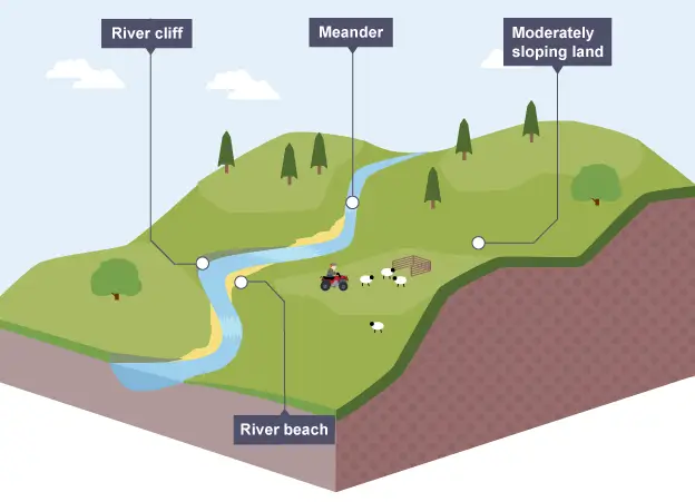
The three stages of river – stage 2 middle course | Image source bbc.co.uk
As the river moves downstream, it enters the middle course, where the gradient becomes gentler and discharge increases due to the addition of tributaries. The river channel widens, and the valley becomes broader and less steep-sided.
In this stage, lateral erosion gains importance alongside vertical erosion. The river begins to erode sideways, reshaping its valley and developing a wider floodplain. Transportation of sediment is more efficient, and deposition starts to occur intermittently, especially during periods of reduced velocity.
Major Landforms of the Middle Course
The most distinctive landforms of the middle course are meanders—sinuous bends in the river channel. Meanders develop as the river swings from side to side, eroding the outer banks (river cliffs) and depositing sediment along the inner banks (slip-off slopes). This process reflects the increasing dominance of lateral erosion.
The valley in this stage often displays an asymmetrical cross profile, with gentler slopes on one side and steeper slopes on the other. Over time, repeated meandering contributes to valley widening and the gradual development of a floodplain.
Another feature associated with this stage is the incipient floodplain, formed by periodic overbank deposition during floods. Though not as extensive as in the lower course, it marks a transition from a purely erosional environment to a mixed erosional–depositional one.
Stage 3: Lower Course (Old Stage)
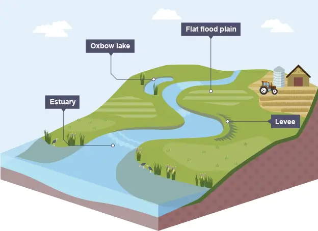
The three stages of river – stage 3 lower course | Image source bbc.co.uk
The lower course represents the final stage of the river’s journey, usually extending across low-lying plains towards the river’s mouth. Here, the gradient is very gentle, discharge is at its maximum, and the river’s velocity is relatively low.
In this stage, deposition becomes the dominant geomorphic process. The river no longer has sufficient energy to carry its entire sediment load, leading to widespread accumulation of alluvium.
Major Landforms of the Lower Course
The most prominent feature of the lower course is the floodplain, a wide, flat area formed by repeated deposition of fine sediments during floods. Floodplains are among the most fertile landforms and have historically attracted dense human settlement.
Meanders become more pronounced and may eventually be cut off from the main channel, forming ox-bow lakes. These crescent-shaped water bodies represent abandoned meander loops and indicate active channel migration.
Near the river’s mouth, deposition may give rise to levees, which are natural embankments formed alongside the channel, and backswamps, which develop in low-lying areas behind levees.
Where conditions are favourable, the river may form a delta, characterised by multiple distributaries and extensive sediment accumulation. Alternatively, strong tidal action may result in an estuary, where deposition is limited.
Integrated View of Three Stages of River
Although the three stages of river development are described separately, they are parts of a continuous system. In reality, different stages may coexist along a river’s course due to variations in lithology, tectonic activity, or climate. For instance, rejuvenation caused by uplift or base-level change may reintroduce youthful features into a mature or old river.
Comparative Study of the Stages of River Course
| Basis of Comparison | Upper Course (Youthful Stage) | Middle Course (Mature Stage) | Lower Course (Old Stage) |
|---|---|---|---|
| Relief & Slope | Steep slope, mountainous or plateau regions | Gentle slope, rolling plains | Almost flat slope, extensive plains |
| River Velocity | Very high | Moderate | Slow-moving |
| Dominant Process | Vertical erosion (down-cutting) | Lateral erosion and transportation | Deposition dominates |
| Valley Shape | Narrow, deep V-shaped valleys | Wider valleys with gentler sides | Extremely wide floodplains |
| Channel Characteristics | Straight, narrow, rocky bed | Wider channel with meanders | Very wide channel, braided or distributary system |
| Major Landforms | Waterfalls, rapids, gorges, potholes | Meanders, river cliffs, slip-off slopes | Floodplains, levees, deltas, oxbow lakes |
| Sediment Load | Large boulders and coarse material | Sand and small pebbles | Fine silt and clay |
| Erosional Power | Maximum | Moderate | Minimum |
| Floodplain Development | Absent | Beginning to develop | Well-developed and extensive |
| Examples (India) | Upper Ganga near Gangotri, Upper Brahmaputra | Middle Ganga Plains, Godavari Plains | Ganga–Brahmaputra Delta, Godavari Delta |
Terms Explained Associated with this Topic
Source: The place or the point where a river starts in its upper course.
Interlocking spurs: Hill that a river meanders around in a V-shaped valley. When viewed from downstream, these spurs appear to be locked together.
Gorge: A deep valley caused by the wearing back of a waterfall.
Waterfall: often occur where the river crosses a band of harder rock.
V-shaped valley: produced in the upper course because the river cuts down faster than the surrounding slopes are eroded.
Meander: the river starts to erode from side to side.
River cliff: the river moves faster on the outside of the bend and cuts into the valley side. The erosion undercuts the ground causing it to collapse, leaving a cliff.
River beach: (slip-off slope) the river moves more slowly on the inside of the bend. It cannot carry the larger pebbles and these are dropped here.
Oxbow lake: during floods the river cuts through the neck of a large meander. The outside bend is left as a shallow lake.
Floodplain: the river is flowing in a very wide, flat valley. When it floods, it spreads over the floodplain.
Levee: during floods the overflowing river is slowed as it leaves its bed. Silt is deposited along the banks first. Over the years the deposits build up into high ridges.
Estuary: the open mouth of the river, where it meets the sea.
Must Read Articles Associated with this Topic
This article is part of a series of articles that clear basic concepts of the drainage system and the river system. Students and aspirants are also advised to refer to the articles mentioned below.
- Drainage System & River System
- River Source & River Mouth
- Three Stages of River
- Three Processes of Rivers — Erosion, Transportation, and Deposition
- River Basin, Catchment Area, and Watershed
- River Tributaries & River Distributaries
- Drainage Patterns & Structural Control
- River Rejuvenation and Associated Fluvial Landforms
NCERT Geography Books and Other Sources
Students and aspirants are also advised to refer to the sources mentioned below.
- NCERT Geography Book of Class 9, Chapter 3: Drainage
- NCERT Geography Book of Class 11, Chapter 3: Drainage System
- BBC Geography: Three stages of river
- Article on Major River System in India created by India- Water Resource Information System (WRIS) by Ministry of Jal Shakti