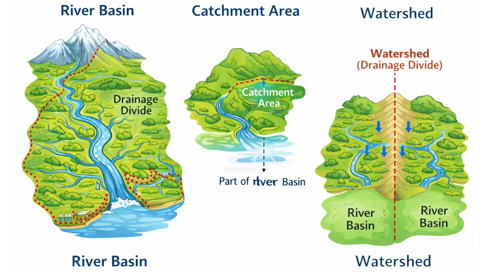
What is a River Basin?
A river basin refers to the entire geographical area drained by a river and all of its tributaries. It is the most comprehensive spatial unit associated with a river system and represents a natural hydrological region within which surface water flow is integrated and directed towards a common outlet.
From a geomorphological perspective, a river basin is shaped over long geological periods through the combined action of erosion, transportation, and deposition by the main river and its tributaries. The basin includes not only the river channels but also hillslopes, floodplains, forests, agricultural land, settlements, and wetlands that contribute runoff to the river system.
River basins are bounded by drainage divides, which are elevated landforms such as ridges, uplands, or mountain ranges that separate one basin from another. Precipitation falling on opposite sides of a divide flows into different river systems, making the basin a naturally defined and self-contained hydrological unit.
In the Indian context, large river basins such as the Ganga Basin, Indus Basin, and Godavari Basin support dense populations and complex economic activities. Their scale makes them critical units for national-level water resource planning, inter-state river disputes, and integrated basin management.
What is a Catchment Area?
The term catchment area is often used in close association with river basins but carries a more functional and hydrological emphasis. A catchment refers to the area from which rainfall is collected and drained into a particular river, stream, lake, or reservoir.
While a river basin denotes the entire drainage area of a major river system, a catchment may relate to:
- A tributary,
- A sub-basin,
- Or even a small stream or man-made reservoir.
Thus, catchments can exist at multiple scales within a single river basin. For example, the Yamuna has its own catchment, which forms a part of the larger Ganga basin.
Hydrologically, the catchment area determines:
- The volume of runoff generated after rainfall,
- The timing of river flow,
- The likelihood of floods and droughts.
The physical characteristics of a catchment—such as slope, soil type, vegetation cover, and land use—strongly influence infiltration, surface runoff, and sediment yield. As a result, catchments are central to applied studies related to flood forecasting, soil conservation, and watershed development programmes.
What is a Watershed?
The concept of a watershed has been interpreted differently across disciplines, leading to some terminological confusion. In classical physical geography, a watershed refers to a ridge, highland, or elevated boundary that separates two adjacent drainage basins or catchments. In this sense, it is synonymous with a drainage divide.
However, in applied hydrology and environmental planning—particularly in India—the term watershed is often used to denote a small hydrological unit, sometimes equivalent to a micro-catchment. This usage is common in watershed management programmes aimed at soil and water conservation in rural and semi-arid areas.
From the geomorphological viewpoint, watersheds play a crucial role in:
- Determining the direction of river flow,
- Guiding the development of drainage patterns,
- Influencing river capture and basin evolution.
Major watersheds, such as the Himalayan watershed, separate large river systems like the Indus and the Ganga, while minor watersheds may divide the catchments of neighbouring tributaries.
Difference between River Basin, Catchment, and Watershed
Although closely related, these three concepts differ in scale and analytical focus.
A river basin is the largest unit, encompassing the entire drainage system of a river from source to mouth. Within this basin exist several catchment areas, each contributing runoff to specific tributaries or sections of the river. Watersheds, in the strict geographical sense, form the boundaries that separate these basins or catchments.
This hierarchical relationship allows geographers and planners to analyse hydrological processes at different spatial levels—from local soil erosion issues to basin-wide water sharing challenges.
Must Read Articles Associated with this Topic
This article is part of a series of articles that clear basic concepts of the drainage system and the river system. Students and aspirants are also advised to refer to the articles mentioned below.
- Drainage System & River System
- River Source & River Mouth
- Three Stages of River
- Three Processes of Rivers — Erosion, Transportation, and Deposition
- River Basin, Catchment Area, and Watershed
- River Tributaries & River Distributaries
- Drainage Patterns & Structural Control
- River Rejuvenation and Associated Fluvial Landforms
NCERT Geography Books and Other Sources
Students and aspirants are also advised to refer to the sources mentioned below.
- NCERT Geography Book of Class 9, Chapter 3: Drainage
- NCERT Geography Book of Class 11, Chapter 3: Drainage System
- Article on Major River System in India created by India- Water Resource Information System (WRIS) by Ministry of Jal Shakti