Meaning and Definition of Drainage System: The term drainage system refers to the natural system of surface water flow through well-defined channels, such as rivers, streams, and tributaries, within a given geographical area. In physical geography, drainage signifies the movement and disposal of excess surface and subsurface water over the land towards lower elevations, ultimately reaching seas, lakes, or inland basins. A drainage system is therefore the integrated network of a main river and its tributaries, governed by regional physiography, geological structure, climate, slope, and vegetation cover.
Meaning and Definition of River System: A river system is the network formed by a main river and its tributaries that together drain a defined area called a drainage basin and carry water to a common outlet such as a sea or lake. It functions as a single hydrological unit collecting and conveying runoff from the basin.
Definition of River
A river is a natural, linear, surface water body that flows continuously or intermittently in a well-defined channel, under the influence of gravity, from a region of higher elevation (source) to a region of lower elevation (mouth). Rivers constitute the most significant agents of fluvial geomorphology, performing the functions of erosion, transportation, and deposition throughout their course.
From a hydrological perspective, a river represents a dynamic open system, receiving inputs (precipitation, groundwater, tributaries), processing them through channel flow, and delivering outputs (water and sediment) to oceans, lakes, or inland basins.
Essential Characteristics of a River
The defining characteristics of a river are not merely physical attributes but reflect its hydrological behaviour, geomorphic role, and spatial continuity. These characteristics distinguish rivers from other surface water bodies such as lakes, wetlands, and canals.
1. Presence of a Definite Channel
A river flows through a clearly defined natural channel, bounded by river banks and a river bed.
- The channel may be narrow and steep in the upper course and wide and shallow in the lower course.
- Unlike sheet flow or surface runoff, river flow is concentrated and directional.
This characteristic is fundamental in distinguishing rivers from unchannelised surface
runoff like floodwater.
2. Directional Flow Governed by Gradient
River flow is unidirectional, always moving from higher to lower elevation, in accordance with the gravitational gradient.
- The slope (gradient) is steep near the source and gradually decreases downstream.
- The gradient controls velocity, erosive power, and sediment load.
This downstream reduction in gradient explains the transition from erosion-dominated upper courses to deposition-dominated lower courses.
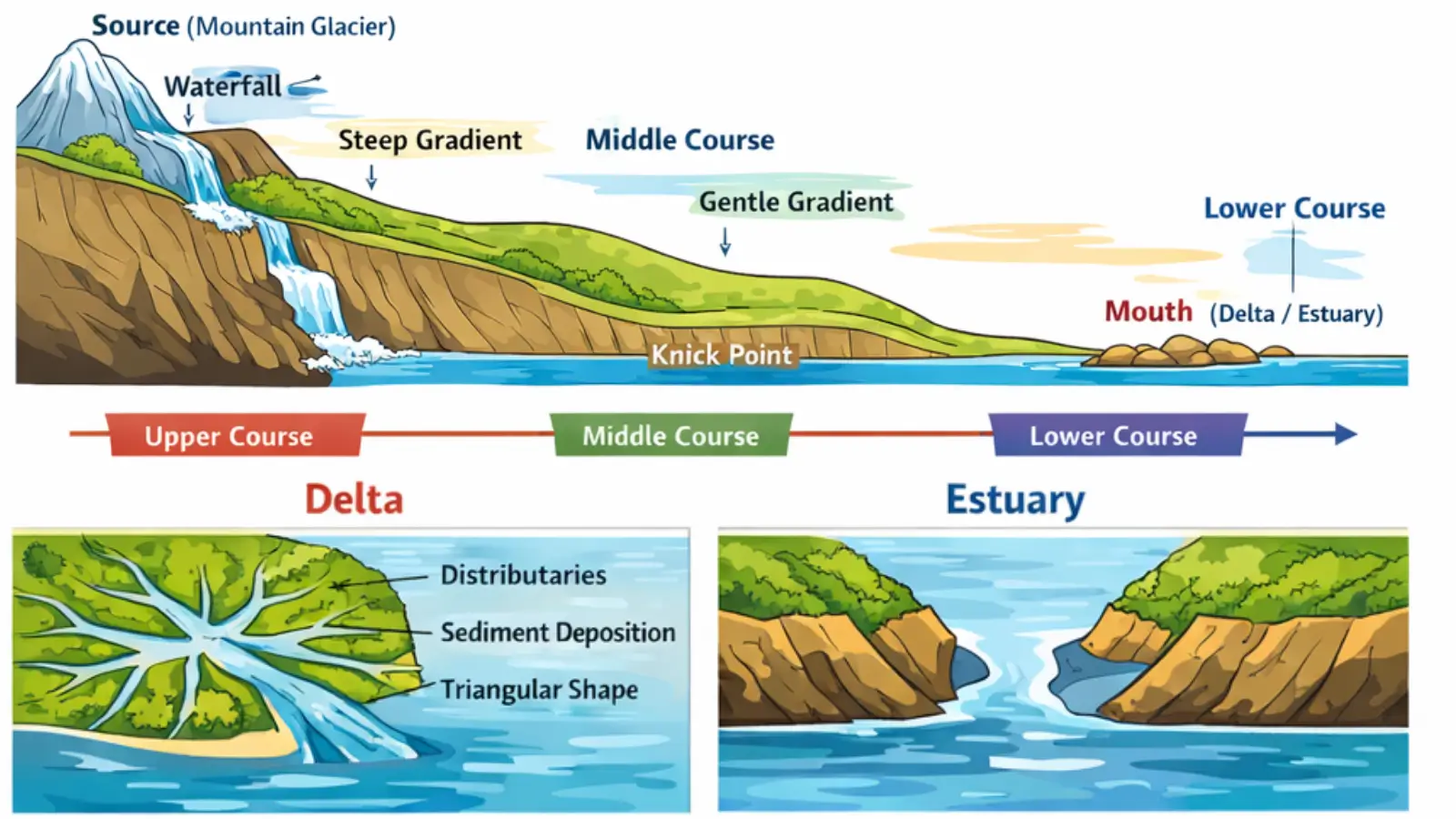
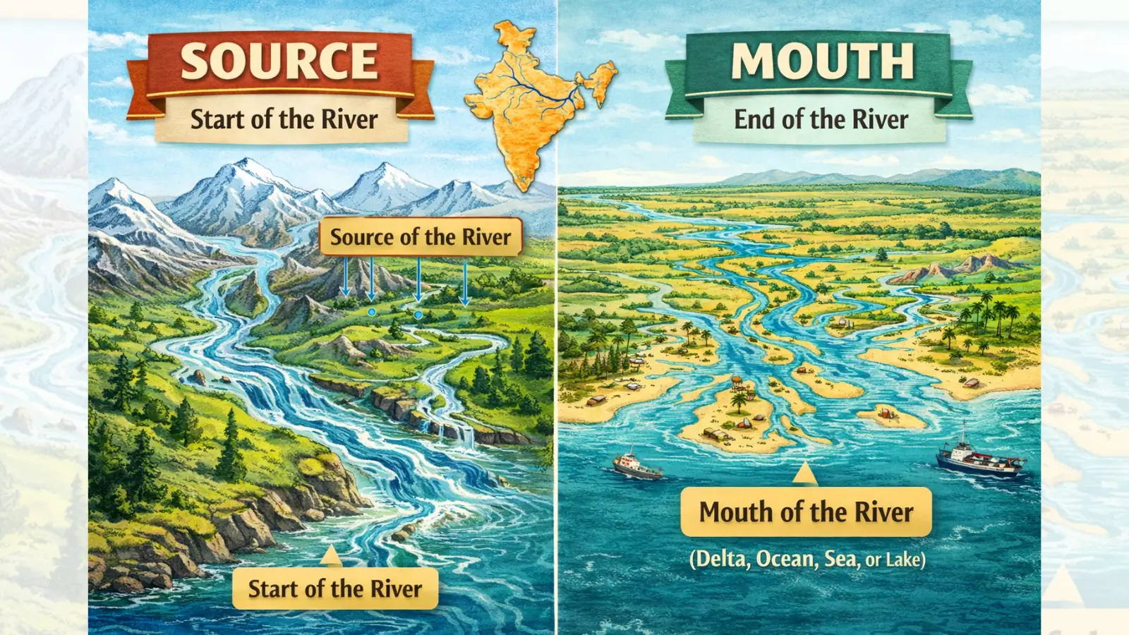
3. Defined Source and Mouth
Every river possesses:
- A source, from where it originates.
- A mouth, where it terminates.
The source may be:
- Glacial
- Spring-fed
- Lake-fed
- Rain-fed
The mouth may form:
- A delta, due to heavy deposition.
- An estuary, due to strong tidal action.
Also read: River Source & River Mouth – Basic Concepts Explained
This linear continuity from source to mouth is a core defining feature of a river system.
4. Continuous Longitudinal Profile
A river develops a longitudinal profile, representing the change in elevation from source to mouth.
- Ideally, this profile is concave upward.
- Irregularities such as knick points, waterfalls, or rapids indicate lithological variation or tectonic disturbance.
The longitudinal profile reflects the river’s stage of geomorphic evolution.
5. Capacity for Erosion, Transportation, and Deposition
A river performs three fundamental geomorphic functions:
- Erosion
- Vertical erosion (downcutting)
- Lateral erosion (side cutting)
- Headward erosion (source extension)
- Transportation
- Dissolved load
- Suspended load
- Bed load
- Deposition
- Occurs when velocity decreases
- Leads to formation of floodplains, deltas, levees, and bars
6. Variable Discharge
River discharge refers to the volume of water flowing through a river channel per unit time.
- Discharge is not constant.
- It varies with:
- Seasonal rainfall
- Snowmelt
- Tributary inflow
- Human interventions (dams, canals)
The variability of discharge explains:
- Floods
- Droughts
- Channel migration
7. Development of a Drainage Network
A river rarely exists in isolation. It forms part of a drainage network, consisting of:
- Main river
- Tributaries
- Sub-tributaries
- Distributaries (near the mouth)
This network drains a specific catchment or river basin, making rivers integral to regional hydrology.
8. Ability to Shape Landforms
Rivers are among the most powerful exogenic geomorphic agents.
They create characteristic fluvial landforms, including:
- V-shaped valleys
- Gorges and canyons
- Meanders
- Ox-bow lakes
- Floodplains
- Deltas and estuaries
Thus, rivers play a central role in landscape evolution.
A river is a dynamic system, constantly adjusting to changes in:
- Base level
- Climate
- Sediment load
- Tectonic movements
This dynamic nature explains phenomena such as:
- River rejuvenation
- Channel shifting
- Avulsion
10. Human Interaction and Utilitarian Significance
Although natural in origin, rivers are closely associated with human activity.
- Sources of water supply
- Irrigation and agriculture
- Hydroelectric power
- Inland navigation
- Cultural and religious significance
This human-river interaction has also altered natural river behaviour through dams, embankments, and interlinking projects.
Must Read Articles Associated with this Topic
This article is part of a series of articles that clear basic concepts of the drainage system and the river system. Students and aspirants are also advised to refer to the articles mentioned below.
- Drainage System & River System
- River Source & River Mouth
- Three Stages of River
- Three Processes of Rivers — Erosion, Transportation, and Deposition
- River Basin, Catchment Area, and Watershed
- River Tributaries & River Distributaries
- Drainage Patterns & Structural Control
- River Rejuvenation and Associated Fluvial Landforms
NCERT Geography Books and Other Sources
Students and aspirants are also advised to refer to the sources mentioned below.
- NCERT Geography Book of Class 9, Chapter 3: Drainage
- NCERT Geography Book of Class 11, Chapter 3: Drainage System
- Article on Major River System in India created by India- Water Resource Information System (WRIS) by Ministry of Jal Shakti